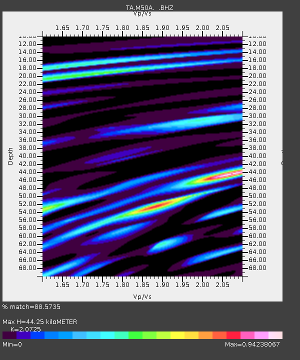
M50A Fremont, OH, USA - Earthquake Result Viewer
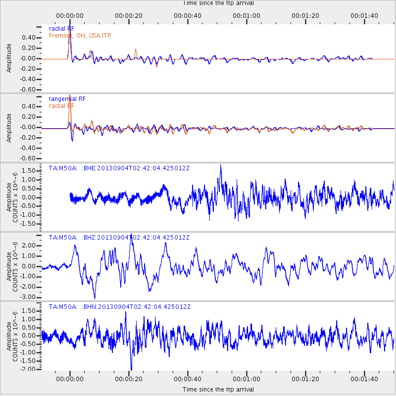
Earthquake location: Andreanof Islands, Aleutian Is.
Earthquake latitude/longitude: 51.6/-174.8
Earthquake time(UTC): 2013/09/04 (247) 02:32:30 GMT
Earthquake Depth: 20 km
Earthquake Magnitude: 6.5 MWW, 5.9 ML, 6.3 MWB, 6.5 MI, 6.5 MWC, 6.5 MWW
Earthquake Catalog/Contributor: NEIC PDE/NEIC COMCAT
Network: TA USArray Transportable Network (new EarthScope stations)
Station: M50A Fremont, OH, USA
Lat/Lon: 41.40 N/83.04 W
Elevation: 176 m
Distance: 60.0 deg
Az: 60.294 deg
Baz: 313.878 deg
Ray Param: 0.06182173
Estimated Moho Depth: 44.25 km
Estimated Crust Vp/Vs: 2.07
Assumed Crust Vp: 6.498 km/s
Estimated Crust Vs: 3.135 km/s
Estimated Crust Poisson's Ratio: 0.35
Radial Match: 88.5735 %
Radial Bump: 400
Transverse Match: 75.989235 %
Transverse Bump: 400
SOD ConfigId: 626651
Insert Time: 2014-04-18 10:16:37.008 +0000
GWidth: 2.5
Max Bumps: 400
Tol: 0.001

Signal To Noise

ChannelStoNSTALTA
TA:M50A: :BHZ:20130904T02:42:04.425012Z6.28999471.0556118E-61.6782396E-7
TA:M50A: :BHN:20130904T02:42:04.425012Z1.8004723.1950123E-71.7745414E-7
TA:M50A: :BHE:20130904T02:42:04.425012Z2.07552054.0806907E-71.9661047E-7
Arrivals
Ps7.6 SECOND
PpPs20 SECOND
PsPs/PpSs28 SECOND