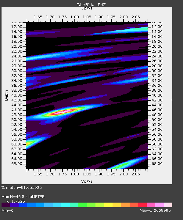
M51A Elyria, OH, USA - Earthquake Result Viewer
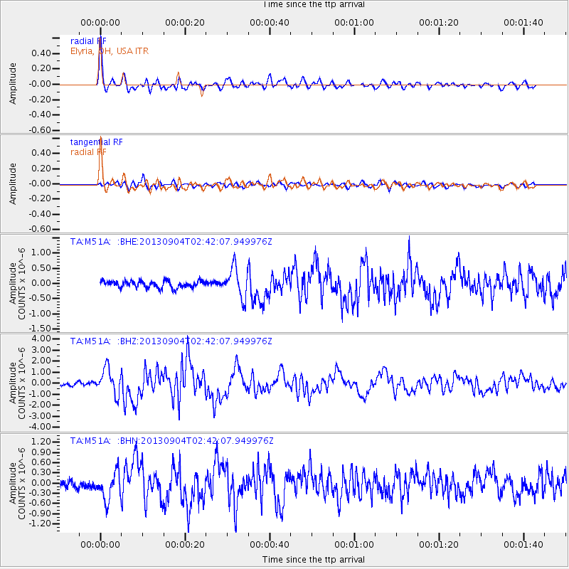
Earthquake location: Andreanof Islands, Aleutian Is.
Earthquake latitude/longitude: 51.6/-174.8
Earthquake time(UTC): 2013/09/04 (247) 02:32:30 GMT
Earthquake Depth: 20 km
Earthquake Magnitude: 6.5 MWW, 5.9 ML, 6.3 MWB, 6.5 MI, 6.5 MWC, 6.5 MWW
Earthquake Catalog/Contributor: NEIC PDE/NEIC COMCAT
Network: TA USArray Transportable Network (new EarthScope stations)
Station: M51A Elyria, OH, USA
Lat/Lon: 41.33 N/82.18 W
Elevation: 239 m
Distance: 60.5 deg
Az: 59.834 deg
Baz: 314.216 deg
Ray Param: 0.061483473
Estimated Moho Depth: 46.5 km
Estimated Crust Vp/Vs: 1.75
Assumed Crust Vp: 6.498 km/s
Estimated Crust Vs: 3.708 km/s
Estimated Crust Poisson's Ratio: 0.26
Radial Match: 91.051025 %
Radial Bump: 400
Transverse Match: 75.37552 %
Transverse Bump: 400
SOD ConfigId: 626651
Insert Time: 2014-04-18 10:16:38.223 +0000
GWidth: 2.5
Max Bumps: 400
Tol: 0.001

Signal To Noise

ChannelStoNSTALTA
TA:M51A: :BHZ:20130904T02:42:07.949976Z8.2311281.1884405E-61.4438368E-7
TA:M51A: :BHN:20130904T02:42:07.949976Z3.48776534.218974E-71.2096497E-7
TA:M51A: :BHE:20130904T02:42:07.949976Z4.488985.075232E-71.1305981E-7
Arrivals
Ps5.7 SECOND
PpPs19 SECOND
PsPs/PpSs24 SECOND