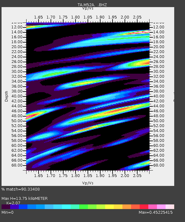
M52A Chesterland, OH, USA - Earthquake Result Viewer
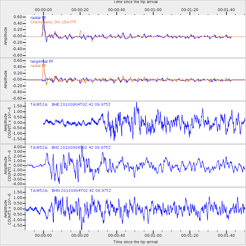
Earthquake location: Andreanof Islands, Aleutian Is.
Earthquake latitude/longitude: 51.6/-174.8
Earthquake time(UTC): 2013/09/04 (247) 02:32:30 GMT
Earthquake Depth: 20 km
Earthquake Magnitude: 6.5 MWW, 5.9 ML, 6.3 MWB, 6.5 MI, 6.5 MWC, 6.5 MWW
Earthquake Catalog/Contributor: NEIC PDE/NEIC COMCAT
Network: TA USArray Transportable Network (new EarthScope stations)
Station: M52A Chesterland, OH, USA
Lat/Lon: 41.54 N/81.36 W
Elevation: 382 m
Distance: 60.8 deg
Az: 59.166 deg
Baz: 314.433 deg
Ray Param: 0.06128593
Estimated Moho Depth: 13.75 km
Estimated Crust Vp/Vs: 2.07
Assumed Crust Vp: 6.483 km/s
Estimated Crust Vs: 3.132 km/s
Estimated Crust Poisson's Ratio: 0.35
Radial Match: 90.33408 %
Radial Bump: 400
Transverse Match: 74.0357 %
Transverse Bump: 400
SOD ConfigId: 626651
Insert Time: 2014-04-18 10:16:41.676 +0000
GWidth: 2.5
Max Bumps: 400
Tol: 0.001

Signal To Noise

ChannelStoNSTALTA
TA:M52A: :BHZ:20130904T02:42:09.975Z5.9607431.3370054E-62.2430181E-7
TA:M52A: :BHN:20130904T02:42:09.975Z2.0839574.0613867E-71.9488824E-7
TA:M52A: :BHE:20130904T02:42:09.975Z3.0533844.3467267E-71.4235768E-7
Arrivals
Ps2.4 SECOND
PpPs6.3 SECOND
PsPs/PpSs8.6 SECOND