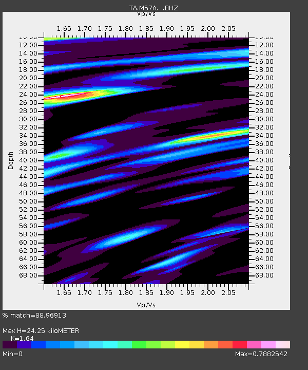
M57A Sunshine Farm, Cogan Station, PA, USA - Earthquake Result Viewer
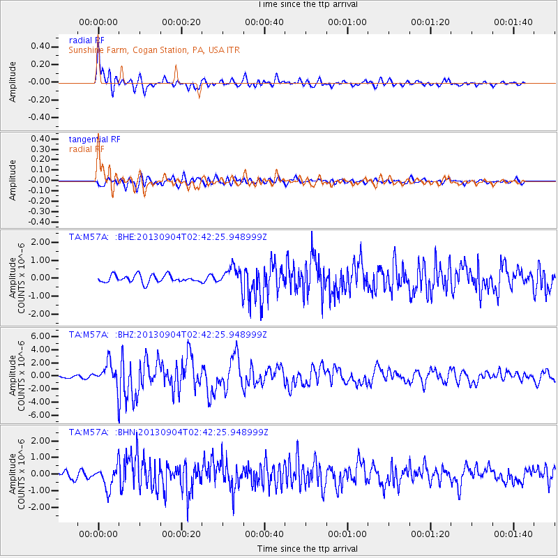
Earthquake location: Andreanof Islands, Aleutian Is.
Earthquake latitude/longitude: 51.6/-174.8
Earthquake time(UTC): 2013/09/04 (247) 02:32:30 GMT
Earthquake Depth: 20 km
Earthquake Magnitude: 6.5 MWW, 5.9 ML, 6.3 MWB, 6.5 MI, 6.5 MWC, 6.5 MWW
Earthquake Catalog/Contributor: NEIC PDE/NEIC COMCAT
Network: TA USArray Transportable Network (new EarthScope stations)
Station: M57A Sunshine Farm, Cogan Station, PA, USA
Lat/Lon: 41.34 N/77.13 W
Elevation: 319 m
Distance: 63.2 deg
Az: 56.769 deg
Baz: 316.095 deg
Ray Param: 0.059736177
Estimated Moho Depth: 24.25 km
Estimated Crust Vp/Vs: 1.64
Assumed Crust Vp: 6.121 km/s
Estimated Crust Vs: 3.732 km/s
Estimated Crust Poisson's Ratio: 0.20
Radial Match: 88.96913 %
Radial Bump: 400
Transverse Match: 73.21554 %
Transverse Bump: 400
SOD ConfigId: 626651
Insert Time: 2014-04-18 10:16:51.762 +0000
GWidth: 2.5
Max Bumps: 400
Tol: 0.001

Signal To Noise

ChannelStoNSTALTA
TA:M57A: :BHZ:20130904T02:42:25.948999Z4.5857481.8515157E-64.037543E-7
TA:M57A: :BHN:20130904T02:42:25.948999Z3.39646226.8718305E-72.0232319E-7
TA:M57A: :BHE:20130904T02:42:25.948999Z2.740425.6153345E-72.049078E-7
Arrivals
Ps2.6 SECOND
PpPs10 SECOND
PsPs/PpSs13 SECOND