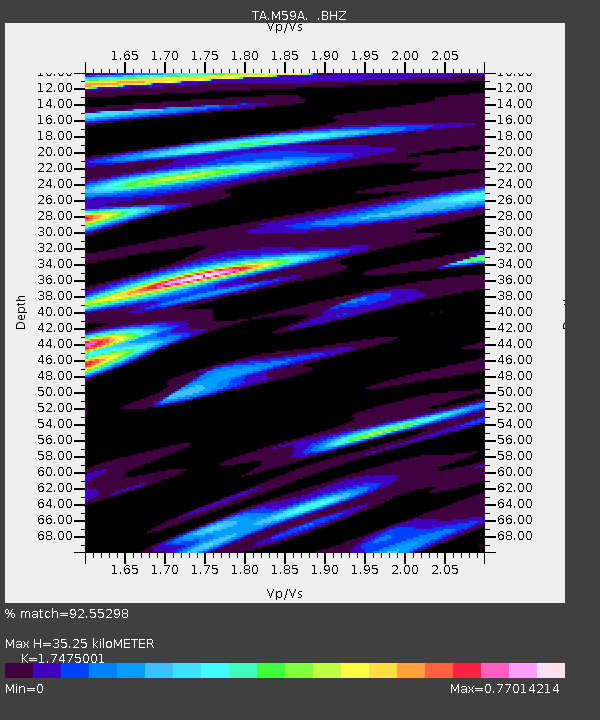
M59A Waymart, PA, USA - Earthquake Result Viewer
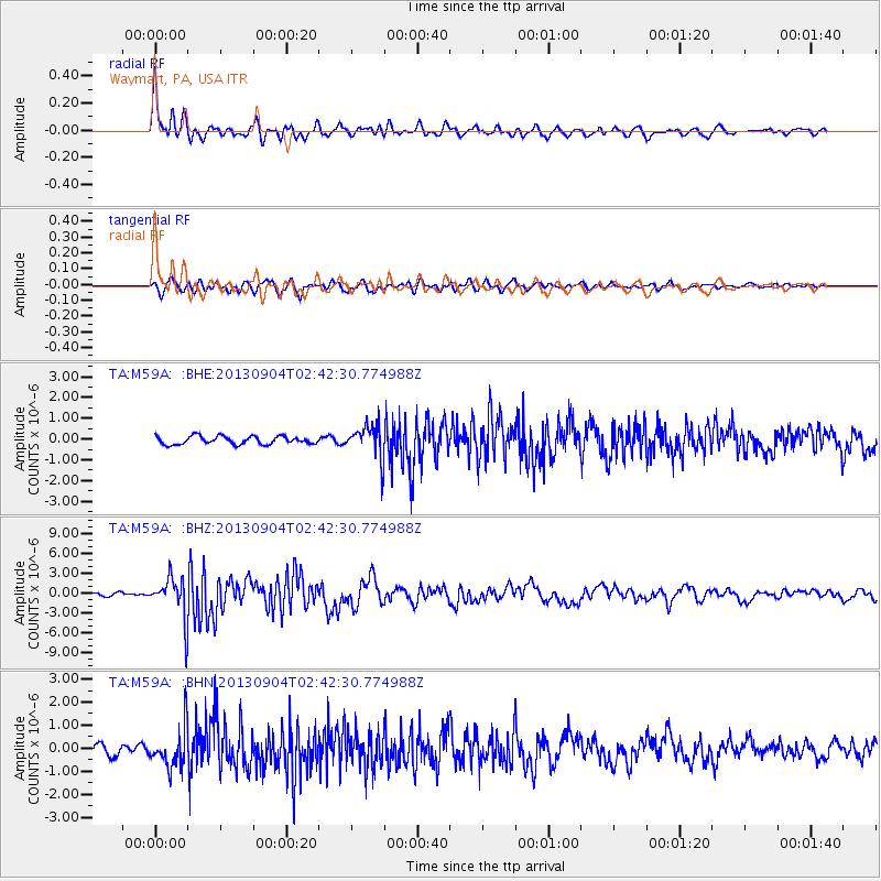
Earthquake location: Andreanof Islands, Aleutian Is.
Earthquake latitude/longitude: 51.6/-174.8
Earthquake time(UTC): 2013/09/04 (247) 02:32:30 GMT
Earthquake Depth: 20 km
Earthquake Magnitude: 6.5 MWW, 5.9 ML, 6.3 MWB, 6.5 MI, 6.5 MWC, 6.5 MWW
Earthquake Catalog/Contributor: NEIC PDE/NEIC COMCAT
Network: TA USArray Transportable Network (new EarthScope stations)
Station: M59A Waymart, PA, USA
Lat/Lon: 41.54 N/75.43 W
Elevation: 471 m
Distance: 63.9 deg
Az: 55.58 deg
Baz: 316.683 deg
Ray Param: 0.059258897
Estimated Moho Depth: 35.25 km
Estimated Crust Vp/Vs: 1.75
Assumed Crust Vp: 6.283 km/s
Estimated Crust Vs: 3.596 km/s
Estimated Crust Poisson's Ratio: 0.26
Radial Match: 92.55298 %
Radial Bump: 400
Transverse Match: 79.9468 %
Transverse Bump: 400
SOD ConfigId: 626651
Insert Time: 2014-04-18 10:16:56.527 +0000
GWidth: 2.5
Max Bumps: 400
Tol: 0.001

Signal To Noise

ChannelStoNSTALTA
TA:M59A: :BHZ:20130904T02:42:30.774988Z12.9933983.0939914E-62.3812028E-7
TA:M59A: :BHN:20130904T02:42:30.774988Z3.56430868.506601E-72.3866062E-7
TA:M59A: :BHE:20130904T02:42:30.774988Z4.08327.813916E-71.9136745E-7
Arrivals
Ps4.4 SECOND
PpPs15 SECOND
PsPs/PpSs19 SECOND