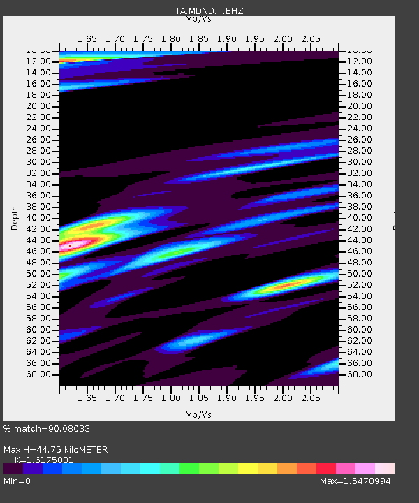
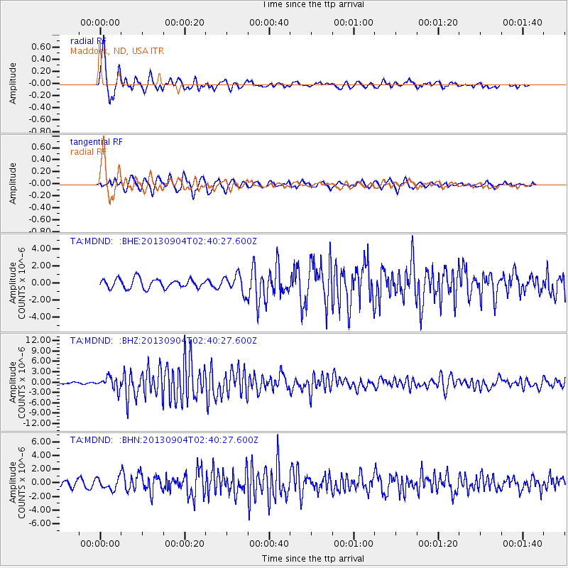
MDND Maddock, ND, USA - Earthquake Result Viewer

Earthquake location: Andreanof Islands, Aleutian Is.
Earthquake latitude/longitude: 51.6/-174.8
Earthquake time(UTC): 2013/09/04 (247) 02:32:30 GMT
Earthquake Depth: 20 km
Earthquake Magnitude: 6.5 MWW, 5.9 ML, 6.3 MWB, 6.5 MI, 6.5 MWC, 6.5 MWW
Earthquake Catalog/Contributor: NEIC PDE/NEIC COMCAT
Network: TA USArray Transportable Network (new EarthScope stations)
Station: MDND Maddock, ND, USA
Lat/Lon: 47.85 N/99.60 W
Elevation: 479 m
Distance: 46.8 deg
Az: 63.355 deg
Baz: 304.064 deg
Ray Param: 0.07041502
Estimated Moho Depth: 44.75 km
Estimated Crust Vp/Vs: 1.62
Assumed Crust Vp: 6.53 km/s
Estimated Crust Vs: 4.037 km/s
Estimated Crust Poisson's Ratio: 0.19
Radial Match: 90.08033 %
Radial Bump: 393
Transverse Match: 73.824394 %
Transverse Bump: 400
SOD ConfigId: 626651
Insert Time: 2014-04-18 10:17:06.018 +0000
GWidth: 2.5
Max Bumps: 400
Tol: 0.001

Signal To Noise

ChannelStoNSTALTA
TA:MDND: :BHZ:20130904T02:40:27.600Z8.6986771.7681343E-62.0326473E-7
TA:MDND: :BHN:20130904T02:40:27.600Z1.58352958.5244113E-75.383172E-7
TA:MDND: :BHE:20130904T02:40:27.600Z2.00958181.0927248E-65.437573E-7
Arrivals
Ps4.5 SECOND
PpPs17 SECOND
PsPs/PpSs21 SECOND