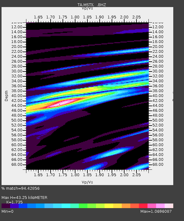
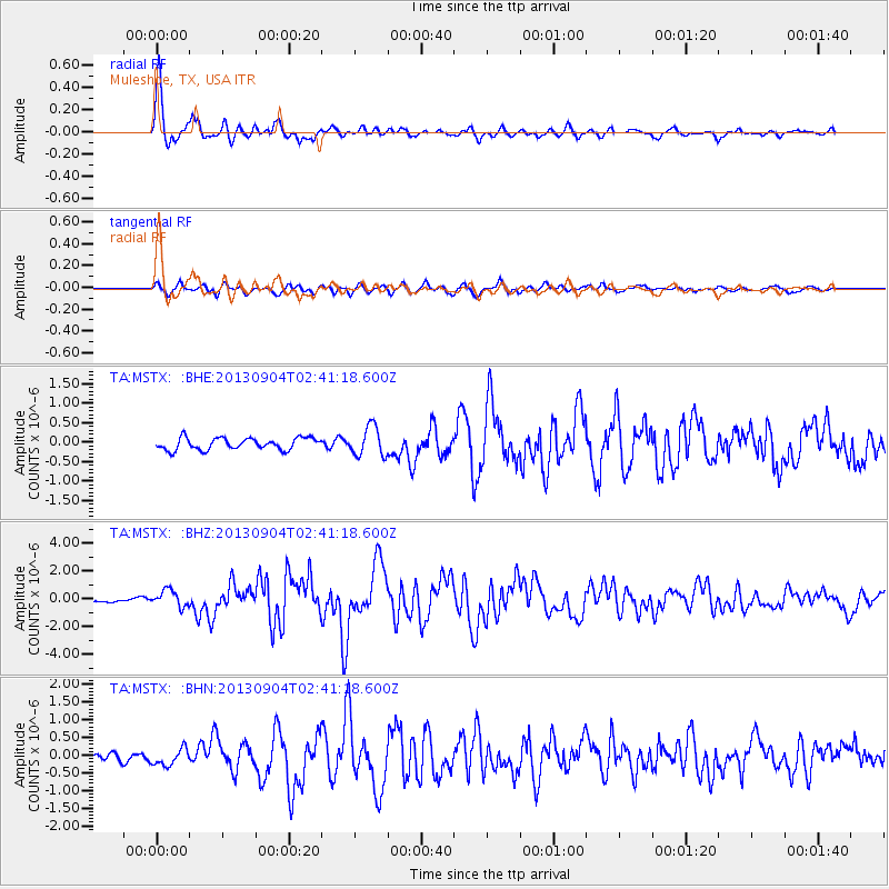
MSTX Muleshoe, TX, USA - Earthquake Result Viewer

Earthquake location: Andreanof Islands, Aleutian Is.
Earthquake latitude/longitude: 51.6/-174.8
Earthquake time(UTC): 2013/09/04 (247) 02:32:30 GMT
Earthquake Depth: 20 km
Earthquake Magnitude: 6.5 MWW, 5.9 ML, 6.3 MWB, 6.5 MI, 6.5 MWC, 6.5 MWW
Earthquake Catalog/Contributor: NEIC PDE/NEIC COMCAT
Network: TA USArray Transportable Network (new EarthScope stations)
Station: MSTX Muleshoe, TX, USA
Lat/Lon: 33.97 N/102.77 W
Elevation: 1167 m
Distance: 53.5 deg
Az: 79.496 deg
Baz: 312.387 deg
Ray Param: 0.06603457
Estimated Moho Depth: 43.25 km
Estimated Crust Vp/Vs: 1.74
Assumed Crust Vp: 6.129 km/s
Estimated Crust Vs: 3.533 km/s
Estimated Crust Poisson's Ratio: 0.25
Radial Match: 94.42856 %
Radial Bump: 400
Transverse Match: 74.54892 %
Transverse Bump: 400
SOD ConfigId: 626651
Insert Time: 2014-04-18 10:17:09.188 +0000
GWidth: 2.5
Max Bumps: 400
Tol: 0.001

Signal To Noise

ChannelStoNSTALTA
TA:MSTX: :BHZ:20130904T02:41:18.600Z4.8208855.9316176E-71.2304001E-7
TA:MSTX: :BHN:20130904T02:41:18.600Z1.48192082.3678298E-71.5978112E-7
TA:MSTX: :BHE:20130904T02:41:18.600Z2.47556143.750902E-71.5151723E-7
Arrivals
Ps5.5 SECOND
PpPs18 SECOND
PsPs/PpSs24 SECOND