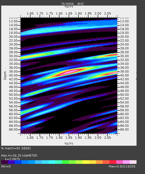
N40A Mertquake, Salem, IA, USA - Earthquake Result Viewer

Earthquake location: Andreanof Islands, Aleutian Is.
Earthquake latitude/longitude: 51.6/-174.8
Earthquake time(UTC): 2013/09/04 (247) 02:32:30 GMT
Earthquake Depth: 20 km
Earthquake Magnitude: 6.5 MWW, 5.9 ML, 6.3 MWB, 6.5 MI, 6.5 MWC, 6.5 MWW
Earthquake Catalog/Contributor: NEIC PDE/NEIC COMCAT
Network: TA USArray Transportable Network (new EarthScope stations)
Station: N40A Mertquake, Salem, IA, USA
Lat/Lon: 40.88 N/91.58 W
Elevation: 208 m
Distance: 55.6 deg
Az: 65.901 deg
Baz: 311.269 deg
Ray Param: 0.06468937
Estimated Moho Depth: 38.25 km
Estimated Crust Vp/Vs: 2.10
Assumed Crust Vp: 6.498 km/s
Estimated Crust Vs: 3.098 km/s
Estimated Crust Poisson's Ratio: 0.35
Radial Match: 91.56581 %
Radial Bump: 335
Transverse Match: 67.55752 %
Transverse Bump: 400
SOD ConfigId: 626651
Insert Time: 2014-04-18 10:17:13.422 +0000
GWidth: 2.5
Max Bumps: 400
Tol: 0.001

Signal To Noise

ChannelStoNSTALTA
TA:N40A: :BHZ:20130904T02:41:33.550012Z10.2414121.2713436E-61.2413753E-7
TA:N40A: :BHN:20130904T02:41:33.550012Z2.92695054.686001E-71.6009841E-7
TA:N40A: :BHE:20130904T02:41:33.550012Z2.62119054.6070411E-71.757614E-7
Arrivals
Ps6.8 SECOND
PpPs17 SECOND
PsPs/PpSs24 SECOND