N47A Urbana, IN, USA - Earthquake Result Viewer
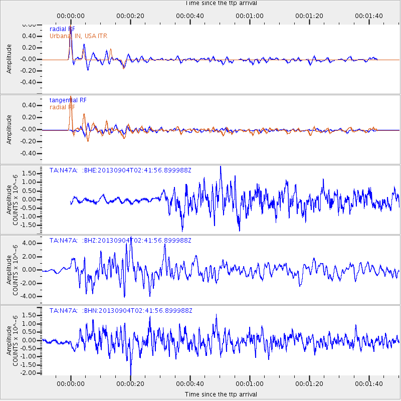
Earthquake location: Andreanof Islands, Aleutian Is.
Earthquake latitude/longitude: 51.6/-174.8
Earthquake time(UTC): 2013/09/04 (247) 02:32:30 GMT
Earthquake Depth: 20 km
Earthquake Magnitude: 6.5 MWW, 5.9 ML, 6.3 MWB, 6.5 MI, 6.5 MWC, 6.5 MWW
Earthquake Catalog/Contributor: NEIC PDE/NEIC COMCAT
Network: TA USArray Transportable Network (new EarthScope stations)
Station: N47A Urbana, IN, USA
Lat/Lon: 40.88 N/85.69 W
Elevation: 252 m
Distance: 58.9 deg
Az: 62.336 deg
Baz: 313.18 deg
Ray Param: 0.062539235
Estimated Moho Depth: 33.0 km
Estimated Crust Vp/Vs: 1.84
Assumed Crust Vp: 6.498 km/s
Estimated Crust Vs: 3.541 km/s
Estimated Crust Poisson's Ratio: 0.29
Radial Match: 90.150185 %
Radial Bump: 400
Transverse Match: 73.06261 %
Transverse Bump: 400
SOD ConfigId: 626651
Insert Time: 2014-04-18 10:17:17.946 +0000
GWidth: 2.5
Max Bumps: 400
Tol: 0.001

Signal To Noise

ChannelStoNSTALTA
TA:N47A: :BHZ:20130904T02:41:56.899988Z6.3173711.1368478E-61.7995585E-7
TA:N47A: :BHN:20130904T02:41:56.899988Z4.33099653.445961E-77.956508E-8
TA:N47A: :BHE:20130904T02:41:56.899988Z3.4296323.8778794E-71.1306984E-7
Arrivals
Ps4.4 SECOND
PpPs14 SECOND
PsPs/PpSs18 SECOND