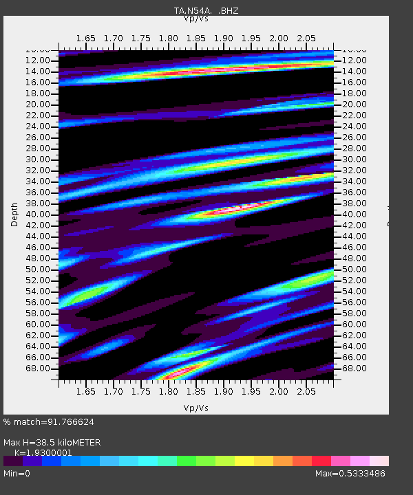
N54A Moraine State Park, Portersville, PA, USA - Earthquake Result Viewer

Earthquake location: Andreanof Islands, Aleutian Is.
Earthquake latitude/longitude: 51.6/-174.8
Earthquake time(UTC): 2013/09/04 (247) 02:32:30 GMT
Earthquake Depth: 20 km
Earthquake Magnitude: 6.5 MWW, 5.9 ML, 6.3 MWB, 6.5 MI, 6.5 MWC, 6.5 MWW
Earthquake Catalog/Contributor: NEIC PDE/NEIC COMCAT
Network: TA USArray Transportable Network (new EarthScope stations)
Station: N54A Moraine State Park, Portersville, PA, USA
Lat/Lon: 40.96 N/79.99 W
Elevation: 408 m
Distance: 61.9 deg
Az: 58.805 deg
Baz: 315.158 deg
Ray Param: 0.06054894
Estimated Moho Depth: 38.5 km
Estimated Crust Vp/Vs: 1.93
Assumed Crust Vp: 6.121 km/s
Estimated Crust Vs: 3.171 km/s
Estimated Crust Poisson's Ratio: 0.32
Radial Match: 91.766624 %
Radial Bump: 400
Transverse Match: 77.86699 %
Transverse Bump: 400
SOD ConfigId: 626651
Insert Time: 2014-04-18 10:17:34.511 +0000
GWidth: 2.5
Max Bumps: 400
Tol: 0.001

Signal To Noise

ChannelStoNSTALTA
TA:N54A: :BHZ:20130904T02:42:17.675012Z6.42628671.6769727E-62.6095515E-7
TA:N54A: :BHN:20130904T02:42:17.675012Z3.1602066.275098E-71.985661E-7
TA:N54A: :BHE:20130904T02:42:17.675012Z4.2286915.084557E-71.2023949E-7
Arrivals
Ps6.1 SECOND
PpPs18 SECOND
PsPs/PpSs24 SECOND