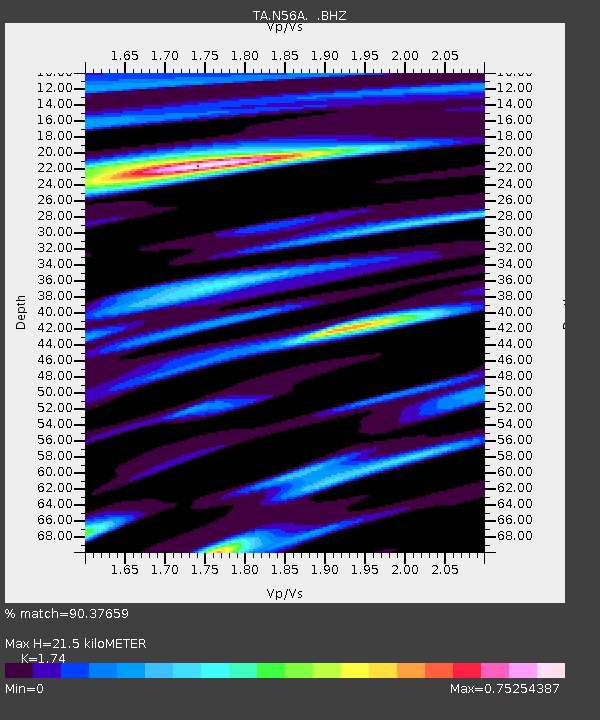
N56A West Decatur, PA, USA - Earthquake Result Viewer
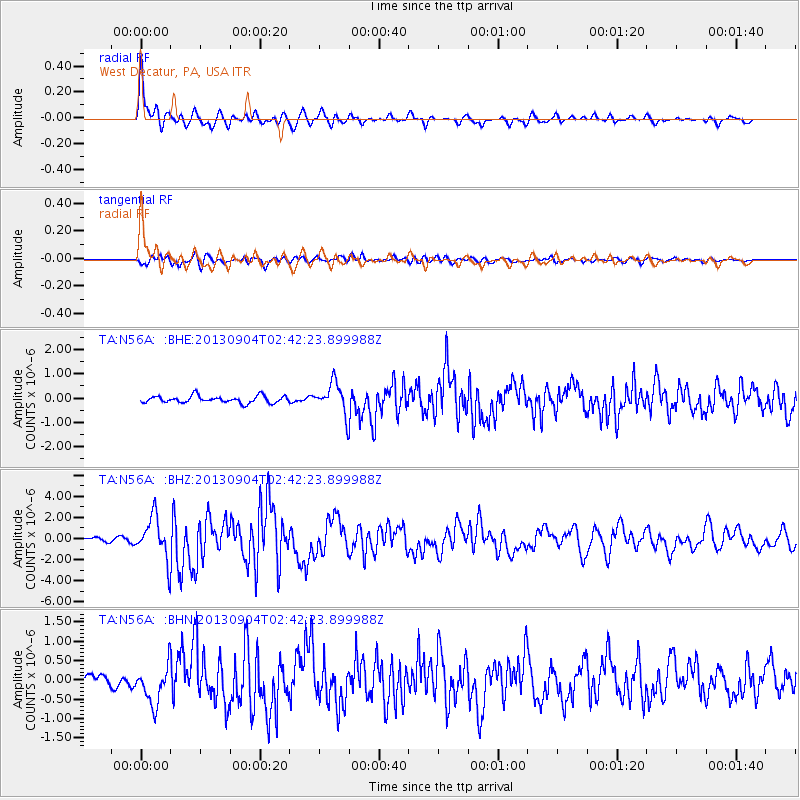
Earthquake location: Andreanof Islands, Aleutian Is.
Earthquake latitude/longitude: 51.6/-174.8
Earthquake time(UTC): 2013/09/04 (247) 02:32:30 GMT
Earthquake Depth: 20 km
Earthquake Magnitude: 6.5 MWW, 5.9 ML, 6.3 MWB, 6.5 MI, 6.5 MWC, 6.5 MWW
Earthquake Catalog/Contributor: NEIC PDE/NEIC COMCAT
Network: TA USArray Transportable Network (new EarthScope stations)
Station: N56A West Decatur, PA, USA
Lat/Lon: 40.92 N/78.30 W
Elevation: 561 m
Distance: 62.8 deg
Az: 57.808 deg
Baz: 315.802 deg
Ray Param: 0.059937797
Estimated Moho Depth: 21.5 km
Estimated Crust Vp/Vs: 1.74
Assumed Crust Vp: 6.121 km/s
Estimated Crust Vs: 3.518 km/s
Estimated Crust Poisson's Ratio: 0.25
Radial Match: 90.37659 %
Radial Bump: 357
Transverse Match: 78.150215 %
Transverse Bump: 400
SOD ConfigId: 626651
Insert Time: 2014-04-18 10:17:39.170 +0000
GWidth: 2.5
Max Bumps: 400
Tol: 0.001

Signal To Noise

ChannelStoNSTALTA
TA:N56A: :BHZ:20130904T02:42:23.899988Z8.3903711.9915872E-62.373658E-7
TA:N56A: :BHN:20130904T02:42:23.899988Z2.98054675.010983E-71.6812297E-7
TA:N56A: :BHE:20130904T02:42:23.899988Z4.48303136.3419634E-71.4146596E-7
Arrivals
Ps2.7 SECOND
PpPs9.2 SECOND
PsPs/PpSs12 SECOND