N59A State Game Land 141, Hazleton, PA, USA - Earthquake Result Viewer
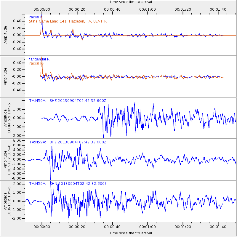
Earthquake location: Andreanof Islands, Aleutian Is.
Earthquake latitude/longitude: 51.6/-174.8
Earthquake time(UTC): 2013/09/04 (247) 02:32:30 GMT
Earthquake Depth: 20 km
Earthquake Magnitude: 6.5 MWW, 5.9 ML, 6.3 MWB, 6.5 MI, 6.5 MWC, 6.5 MWW
Earthquake Catalog/Contributor: NEIC PDE/NEIC COMCAT
Network: TA USArray Transportable Network (new EarthScope stations)
Station: N59A State Game Land 141, Hazleton, PA, USA
Lat/Lon: 40.92 N/75.77 W
Elevation: 508 m
Distance: 64.2 deg
Az: 56.263 deg
Baz: 316.76 deg
Ray Param: 0.059073642
Estimated Moho Depth: 43.25 km
Estimated Crust Vp/Vs: 1.73
Assumed Crust Vp: 6.283 km/s
Estimated Crust Vs: 3.632 km/s
Estimated Crust Poisson's Ratio: 0.25
Radial Match: 92.42313 %
Radial Bump: 400
Transverse Match: 80.82396 %
Transverse Bump: 400
SOD ConfigId: 626651
Insert Time: 2014-04-18 10:17:46.064 +0000
GWidth: 2.5
Max Bumps: 400
Tol: 0.001

Signal To Noise

ChannelStoNSTALTA
TA:N59A: :BHZ:20130904T02:42:32.600Z7.51424261.8487814E-62.4603696E-7
TA:N59A: :BHN:20130904T02:42:32.600Z2.84995535.388045E-71.8905718E-7
TA:N59A: :BHE:20130904T02:42:32.600Z3.08105785.73051E-71.8599164E-7
Arrivals
Ps5.2 SECOND
PpPs18 SECOND
PsPs/PpSs23 SECOND