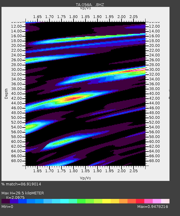
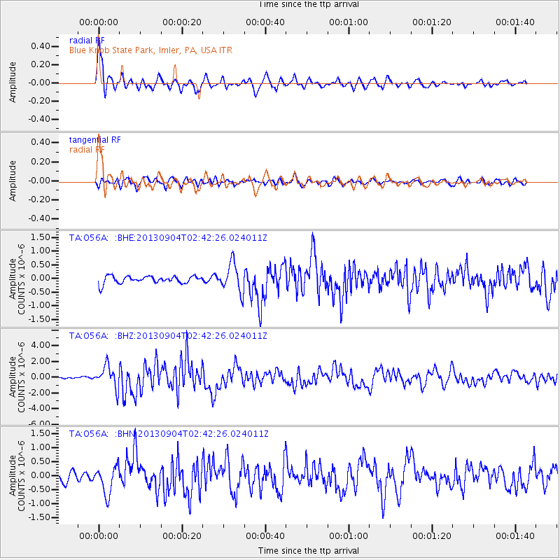
O56A Blue Knob State Park, Imler, PA, USA - Earthquake Result Viewer

Earthquake location: Andreanof Islands, Aleutian Is.
Earthquake latitude/longitude: 51.6/-174.8
Earthquake time(UTC): 2013/09/04 (247) 02:32:30 GMT
Earthquake Depth: 20 km
Earthquake Magnitude: 6.5 MWW, 5.9 ML, 6.3 MWB, 6.5 MI, 6.5 MWC, 6.5 MWW
Earthquake Catalog/Contributor: NEIC PDE/NEIC COMCAT
Network: TA USArray Transportable Network (new EarthScope stations)
Station: O56A Blue Knob State Park, Imler, PA, USA
Lat/Lon: 40.27 N/78.57 W
Elevation: 684 m
Distance: 63.2 deg
Az: 58.48 deg
Baz: 315.931 deg
Ray Param: 0.059729725
Estimated Moho Depth: 29.5 km
Estimated Crust Vp/Vs: 2.10
Assumed Crust Vp: 6.121 km/s
Estimated Crust Vs: 2.918 km/s
Estimated Crust Poisson's Ratio: 0.35
Radial Match: 86.919014 %
Radial Bump: 400
Transverse Match: 66.61599 %
Transverse Bump: 400
SOD ConfigId: 626651
Insert Time: 2014-04-18 10:18:16.174 +0000
GWidth: 2.5
Max Bumps: 400
Tol: 0.001

Signal To Noise

ChannelStoNSTALTA
TA:O56A: :BHZ:20130904T02:42:26.024011Z10.60586551.4434421E-61.3609848E-7
TA:O56A: :BHN:20130904T02:42:26.024011Z3.6928085.178448E-71.4023064E-7
TA:O56A: :BHE:20130904T02:42:26.024011Z4.01340345.3873663E-71.3423436E-7
Arrivals
Ps5.5 SECOND
PpPs14 SECOND
PsPs/PpSs20 SECOND