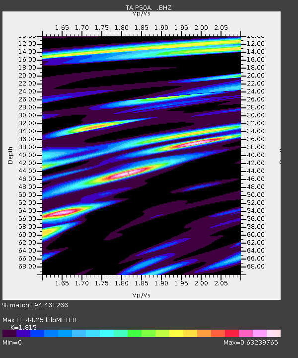
P50A Jamestown, OH, USA - Earthquake Result Viewer
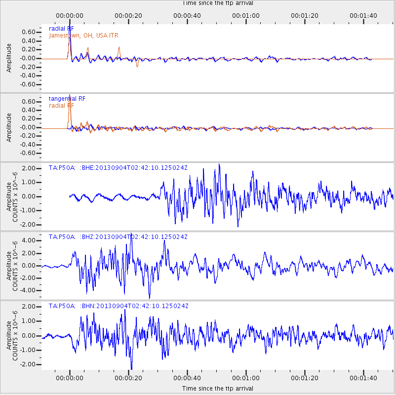
Earthquake location: Andreanof Islands, Aleutian Is.
Earthquake latitude/longitude: 51.6/-174.8
Earthquake time(UTC): 2013/09/04 (247) 02:32:30 GMT
Earthquake Depth: 20 km
Earthquake Magnitude: 6.5 MWW, 5.9 ML, 6.3 MWB, 6.5 MI, 6.5 MWC, 6.5 MWW
Earthquake Catalog/Contributor: NEIC PDE/NEIC COMCAT
Network: TA USArray Transportable Network (new EarthScope stations)
Station: P50A Jamestown, OH, USA
Lat/Lon: 39.61 N/83.80 W
Elevation: 318 m
Distance: 60.8 deg
Az: 62.236 deg
Baz: 314.349 deg
Ray Param: 0.061272256
Estimated Moho Depth: 44.25 km
Estimated Crust Vp/Vs: 1.82
Assumed Crust Vp: 6.232 km/s
Estimated Crust Vs: 3.433 km/s
Estimated Crust Poisson's Ratio: 0.28
Radial Match: 94.461266 %
Radial Bump: 388
Transverse Match: 73.14578 %
Transverse Bump: 400
SOD ConfigId: 626651
Insert Time: 2014-04-18 10:18:39.775 +0000
GWidth: 2.5
Max Bumps: 400
Tol: 0.001

Signal To Noise

ChannelStoNSTALTA
TA:P50A: :BHZ:20130904T02:42:10.125024Z6.4298661.3144096E-62.0442253E-7
TA:P50A: :BHN:20130904T02:42:10.125024Z4.5970866.0723613E-71.3209153E-7
TA:P50A: :BHE:20130904T02:42:10.125024Z3.67593125.142707E-71.3990216E-7
Arrivals
Ps6.0 SECOND
PpPs19 SECOND
PsPs/PpSs25 SECOND