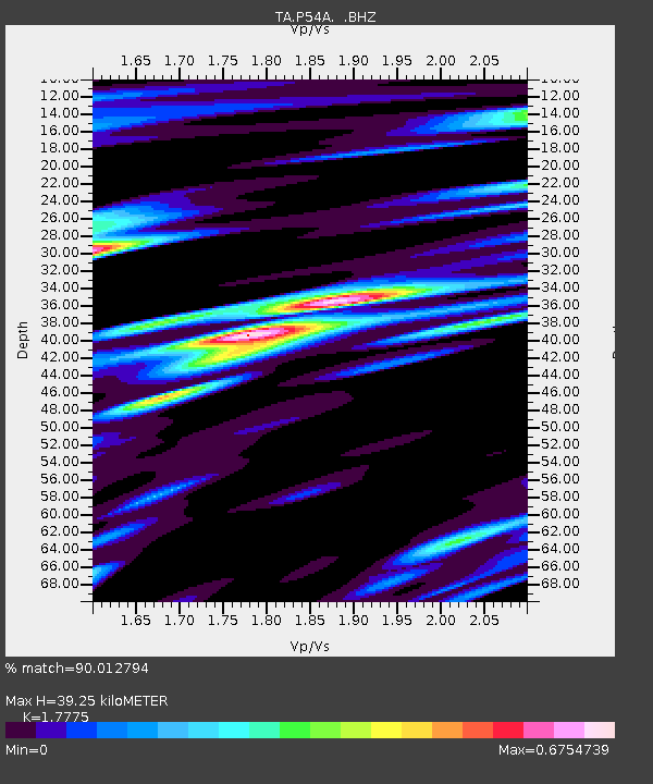
P54A Burton, WV, USA - Earthquake Result Viewer
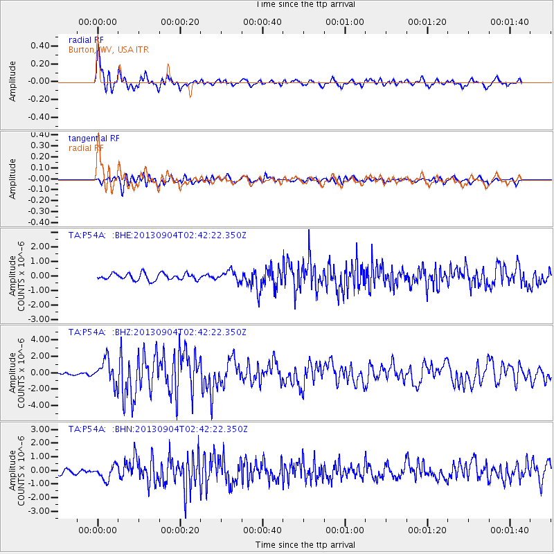
Earthquake location: Andreanof Islands, Aleutian Is.
Earthquake latitude/longitude: 51.6/-174.8
Earthquake time(UTC): 2013/09/04 (247) 02:32:30 GMT
Earthquake Depth: 20 km
Earthquake Magnitude: 6.5 MWW, 5.9 ML, 6.3 MWB, 6.5 MI, 6.5 MWC, 6.5 MWW
Earthquake Catalog/Contributor: NEIC PDE/NEIC COMCAT
Network: TA USArray Transportable Network (new EarthScope stations)
Station: P54A Burton, WV, USA
Lat/Lon: 39.61 N/80.48 W
Elevation: 473 m
Distance: 62.6 deg
Az: 60.18 deg
Baz: 315.482 deg
Ray Param: 0.060089696
Estimated Moho Depth: 39.25 km
Estimated Crust Vp/Vs: 1.78
Assumed Crust Vp: 6.207 km/s
Estimated Crust Vs: 3.492 km/s
Estimated Crust Poisson's Ratio: 0.27
Radial Match: 90.012794 %
Radial Bump: 400
Transverse Match: 77.81721 %
Transverse Bump: 400
SOD ConfigId: 626651
Insert Time: 2014-04-18 10:18:48.801 +0000
GWidth: 2.5
Max Bumps: 400
Tol: 0.001

Signal To Noise

ChannelStoNSTALTA
TA:P54A: :BHZ:20130904T02:42:22.350Z8.4049351.5197465E-61.8081599E-7
TA:P54A: :BHN:20130904T02:42:22.350Z3.08367095.241643E-71.6998064E-7
TA:P54A: :BHE:20130904T02:42:22.350Z1.5686583.5989368E-72.2942776E-7
Arrivals
Ps5.1 SECOND
PpPs17 SECOND
PsPs/PpSs22 SECOND