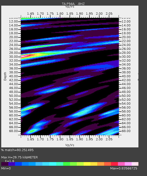
P56A Dayton Farm, Ripley, WV, USA - Earthquake Result Viewer

Earthquake location: Andreanof Islands, Aleutian Is.
Earthquake latitude/longitude: 51.6/-174.8
Earthquake time(UTC): 2013/09/04 (247) 02:32:30 GMT
Earthquake Depth: 20 km
Earthquake Magnitude: 6.5 MWW, 5.9 ML, 6.3 MWB, 6.5 MI, 6.5 MWC, 6.5 MWW
Earthquake Catalog/Contributor: NEIC PDE/NEIC COMCAT
Network: TA USArray Transportable Network (new EarthScope stations)
Station: P56A Dayton Farm, Ripley, WV, USA
Lat/Lon: 39.50 N/78.84 W
Elevation: 249 m
Distance: 63.6 deg
Az: 59.242 deg
Baz: 316.099 deg
Ray Param: 0.05946857
Estimated Moho Depth: 29.75 km
Estimated Crust Vp/Vs: 1.60
Assumed Crust Vp: 6.159 km/s
Estimated Crust Vs: 3.849 km/s
Estimated Crust Poisson's Ratio: 0.18
Radial Match: 90.251495 %
Radial Bump: 400
Transverse Match: 82.84217 %
Transverse Bump: 400
SOD ConfigId: 626651
Insert Time: 2014-04-18 10:18:53.891 +0000
GWidth: 2.5
Max Bumps: 400
Tol: 0.001

Signal To Noise

ChannelStoNSTALTA
TA:P56A: :BHZ:20130904T02:42:28.673975Z8.3752561.5927598E-61.9017446E-7
TA:P56A: :BHN:20130904T02:42:28.673975Z3.26997334.9030444E-71.4994141E-7
TA:P56A: :BHE:20130904T02:42:28.673975Z2.86880874.3734238E-71.5244737E-7
Arrivals
Ps3.0 SECOND
PpPs12 SECOND
PsPs/PpSs15 SECOND