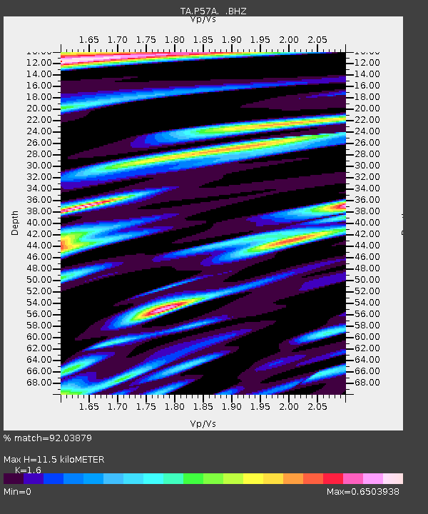
P57A Homestead Farm, Martinsburg, WV, USA - Earthquake Result Viewer
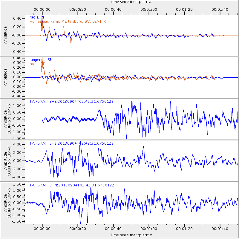
Earthquake location: Andreanof Islands, Aleutian Is.
Earthquake latitude/longitude: 51.6/-174.8
Earthquake time(UTC): 2013/09/04 (247) 02:32:30 GMT
Earthquake Depth: 20 km
Earthquake Magnitude: 6.5 MWW, 5.9 ML, 6.3 MWB, 6.5 MI, 6.5 MWC, 6.5 MWW
Earthquake Catalog/Contributor: NEIC PDE/NEIC COMCAT
Network: TA USArray Transportable Network (new EarthScope stations)
Station: P57A Homestead Farm, Martinsburg, WV, USA
Lat/Lon: 39.48 N/78.01 W
Elevation: 191 m
Distance: 64.0 deg
Az: 58.743 deg
Baz: 316.402 deg
Ray Param: 0.05916697
Estimated Moho Depth: 11.5 km
Estimated Crust Vp/Vs: 1.60
Assumed Crust Vp: 6.159 km/s
Estimated Crust Vs: 3.849 km/s
Estimated Crust Poisson's Ratio: 0.18
Radial Match: 92.03879 %
Radial Bump: 400
Transverse Match: 80.563995 %
Transverse Bump: 400
SOD ConfigId: 626651
Insert Time: 2014-04-18 10:18:55.018 +0000
GWidth: 2.5
Max Bumps: 400
Tol: 0.001

Signal To Noise

ChannelStoNSTALTA
TA:P57A: :BHZ:20130904T02:42:31.675012Z9.0097611.3818449E-61.5337197E-7
TA:P57A: :BHN:20130904T02:42:31.675012Z3.7949554.4041005E-71.16051446E-7
TA:P57A: :BHE:20130904T02:42:31.675012Z3.5935383.7944372E-71.0559056E-7
Arrivals
Ps1.2 SECOND
PpPs4.6 SECOND
PsPs/PpSs5.8 SECOND