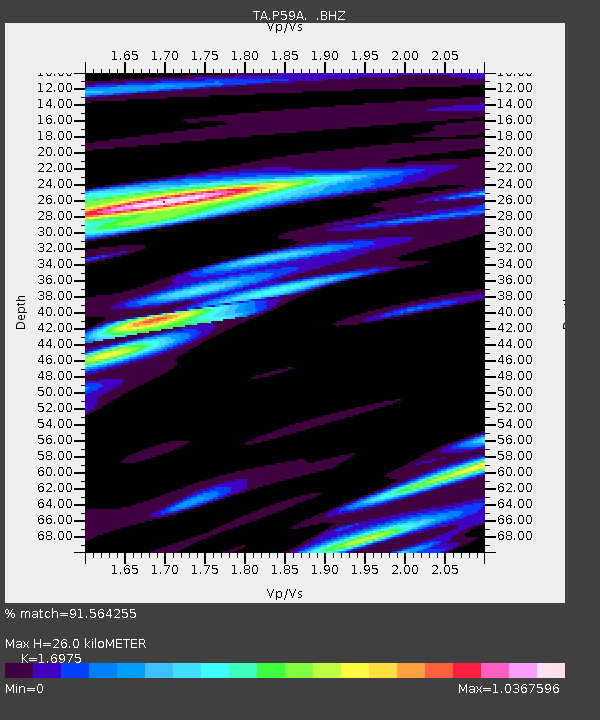
P59A Jarrettsville, MD, USA - Earthquake Result Viewer
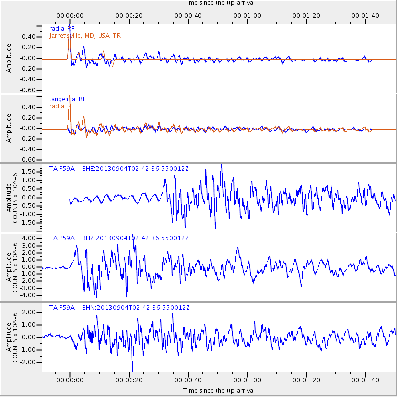
Earthquake location: Andreanof Islands, Aleutian Is.
Earthquake latitude/longitude: 51.6/-174.8
Earthquake time(UTC): 2013/09/04 (247) 02:32:30 GMT
Earthquake Depth: 20 km
Earthquake Magnitude: 6.5 MWW, 5.9 ML, 6.3 MWB, 6.5 MI, 6.5 MWC, 6.5 MWW
Earthquake Catalog/Contributor: NEIC PDE/NEIC COMCAT
Network: TA USArray Transportable Network (new EarthScope stations)
Station: P59A Jarrettsville, MD, USA
Lat/Lon: 39.61 N/76.43 W
Elevation: 157 m
Distance: 64.8 deg
Az: 57.662 deg
Baz: 316.937 deg
Ray Param: 0.0586849
Estimated Moho Depth: 26.0 km
Estimated Crust Vp/Vs: 1.70
Assumed Crust Vp: 6.419 km/s
Estimated Crust Vs: 3.782 km/s
Estimated Crust Poisson's Ratio: 0.23
Radial Match: 91.564255 %
Radial Bump: 400
Transverse Match: 77.188034 %
Transverse Bump: 400
SOD ConfigId: 626651
Insert Time: 2014-04-18 10:18:59.492 +0000
GWidth: 2.5
Max Bumps: 400
Tol: 0.001

Signal To Noise

ChannelStoNSTALTA
TA:P59A: :BHZ:20130904T02:42:36.550012Z12.1095771.5525765E-61.2821063E-7
TA:P59A: :BHN:20130904T02:42:36.550012Z2.81837034.0731206E-71.4452043E-7
TA:P59A: :BHE:20130904T02:42:36.550012Z3.75456245.658866E-71.5071971E-7
Arrivals
Ps3.0 SECOND
PpPs10 SECOND
PsPs/PpSs13 SECOND