Q24A Divide, CO, USA - Earthquake Result Viewer
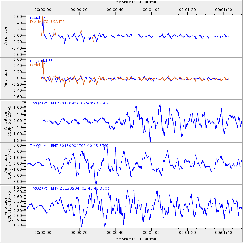
Earthquake location: Andreanof Islands, Aleutian Is.
Earthquake latitude/longitude: 51.6/-174.8
Earthquake time(UTC): 2013/09/04 (247) 02:32:30 GMT
Earthquake Depth: 20 km
Earthquake Magnitude: 6.5 MWW, 5.9 ML, 6.3 MWB, 6.5 MI, 6.5 MWC, 6.5 MWW
Earthquake Catalog/Contributor: NEIC PDE/NEIC COMCAT
Network: TA USArray Transportable Network (new EarthScope stations)
Station: Q24A Divide, CO, USA
Lat/Lon: 38.96 N/105.15 W
Elevation: 2775 m
Distance: 48.8 deg
Az: 76.246 deg
Baz: 308.938 deg
Ray Param: 0.06909677
Estimated Moho Depth: 38.75 km
Estimated Crust Vp/Vs: 1.86
Assumed Crust Vp: 6.159 km/s
Estimated Crust Vs: 3.316 km/s
Estimated Crust Poisson's Ratio: 0.30
Radial Match: 90.775665 %
Radial Bump: 400
Transverse Match: 77.284004 %
Transverse Bump: 400
SOD ConfigId: 626651
Insert Time: 2014-04-18 10:19:08.055 +0000
GWidth: 2.5
Max Bumps: 400
Tol: 0.001

Signal To Noise

ChannelStoNSTALTA
TA:Q24A: :BHZ:20130904T02:40:43.350Z3.86071235.495432E-71.4234244E-7
TA:Q24A: :BHN:20130904T02:40:43.350Z2.56219272.2937559E-78.9523155E-8
TA:Q24A: :BHE:20130904T02:40:43.350Z1.29317311.5895756E-71.2292055E-7
Arrivals
Ps5.7 SECOND
PpPs17 SECOND
PsPs/PpSs23 SECOND