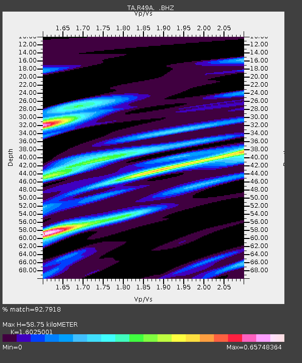
R49A Shelbyville, KY, USA - Earthquake Result Viewer
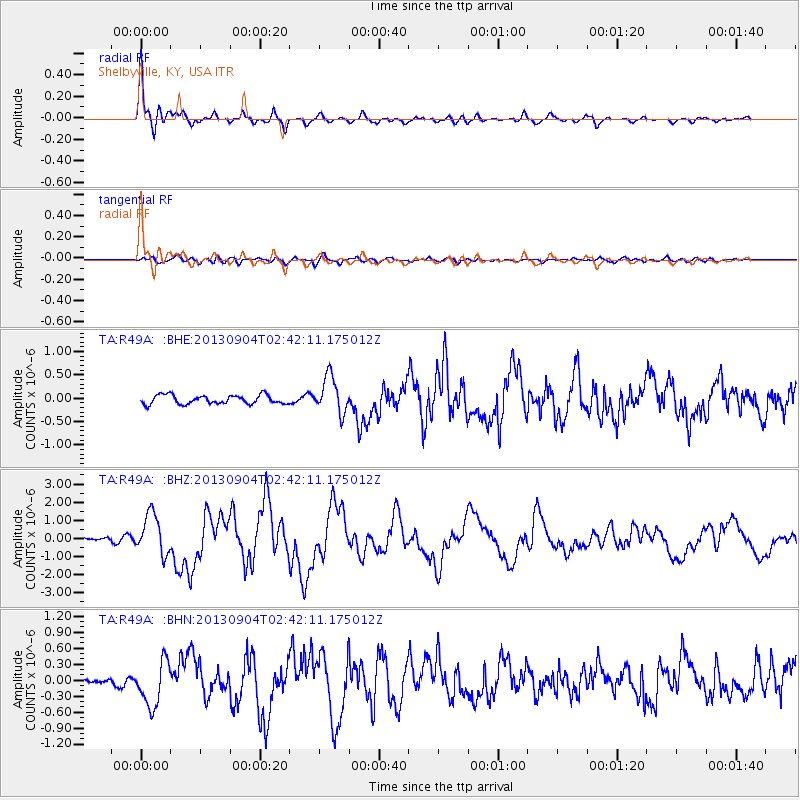
Earthquake location: Andreanof Islands, Aleutian Is.
Earthquake latitude/longitude: 51.6/-174.8
Earthquake time(UTC): 2013/09/04 (247) 02:32:30 GMT
Earthquake Depth: 20 km
Earthquake Magnitude: 6.5 MWW, 5.9 ML, 6.3 MWB, 6.5 MI, 6.5 MWC, 6.5 MWW
Earthquake Catalog/Contributor: NEIC PDE/NEIC COMCAT
Network: TA USArray Transportable Network (new EarthScope stations)
Station: R49A Shelbyville, KY, USA
Lat/Lon: 38.29 N/85.17 W
Elevation: 251 m
Distance: 61.0 deg
Az: 64.169 deg
Baz: 314.431 deg
Ray Param: 0.06116974
Estimated Moho Depth: 58.75 km
Estimated Crust Vp/Vs: 1.60
Assumed Crust Vp: 6.498 km/s
Estimated Crust Vs: 4.055 km/s
Estimated Crust Poisson's Ratio: 0.18
Radial Match: 92.7918 %
Radial Bump: 400
Transverse Match: 65.09983 %
Transverse Bump: 400
SOD ConfigId: 626651
Insert Time: 2014-04-18 10:19:45.396 +0000
GWidth: 2.5
Max Bumps: 400
Tol: 0.001

Signal To Noise

ChannelStoNSTALTA
TA:R49A: :BHZ:20130904T02:42:11.175012Z12.4815761.1047327E-68.8509076E-8
TA:R49A: :BHN:20130904T02:42:11.175012Z6.000034.2105296E-77.017514E-8
TA:R49A: :BHE:20130904T02:42:11.175012Z4.11245443.9220066E-79.5368996E-8
Arrivals
Ps5.7 SECOND
PpPs22 SECOND
PsPs/PpSs28 SECOND