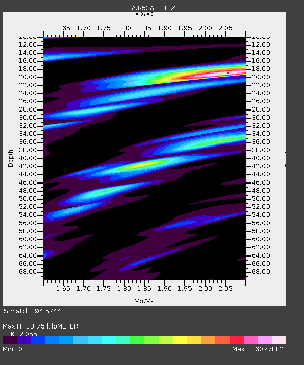
R53A Hurricane, WV, USA - Earthquake Result Viewer
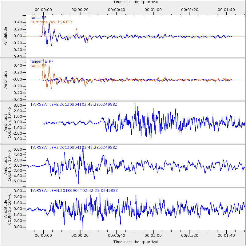
Earthquake location: Andreanof Islands, Aleutian Is.
Earthquake latitude/longitude: 51.6/-174.8
Earthquake time(UTC): 2013/09/04 (247) 02:32:30 GMT
Earthquake Depth: 20 km
Earthquake Magnitude: 6.5 MWW, 5.9 ML, 6.3 MWB, 6.5 MI, 6.5 MWC, 6.5 MWW
Earthquake Catalog/Contributor: NEIC PDE/NEIC COMCAT
Network: TA USArray Transportable Network (new EarthScope stations)
Station: R53A Hurricane, WV, USA
Lat/Lon: 38.33 N/81.95 W
Elevation: 294 m
Distance: 62.7 deg
Az: 62.108 deg
Baz: 315.446 deg
Ray Param: 0.06002151
Estimated Moho Depth: 18.75 km
Estimated Crust Vp/Vs: 2.06
Assumed Crust Vp: 6.207 km/s
Estimated Crust Vs: 3.02 km/s
Estimated Crust Poisson's Ratio: 0.34
Radial Match: 94.5744 %
Radial Bump: 400
Transverse Match: 76.33006 %
Transverse Bump: 400
SOD ConfigId: 626651
Insert Time: 2014-04-18 10:19:54.947 +0000
GWidth: 2.5
Max Bumps: 400
Tol: 0.001

Signal To Noise

ChannelStoNSTALTA
TA:R53A: :BHZ:20130904T02:42:23.024988Z7.5708761.5505025E-62.047983E-7
TA:R53A: :BHN:20130904T02:42:23.024988Z3.57088075.5458395E-71.5530733E-7
TA:R53A: :BHE:20130904T02:42:23.024988Z3.70382125.800177E-71.5659981E-7
Arrivals
Ps3.3 SECOND
PpPs8.9 SECOND
PsPs/PpSs12 SECOND