R58A Rapidan, VA, USA - Earthquake Result Viewer
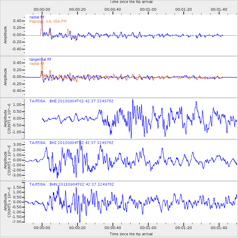
Earthquake location: Andreanof Islands, Aleutian Is.
Earthquake latitude/longitude: 51.6/-174.8
Earthquake time(UTC): 2013/09/04 (247) 02:32:30 GMT
Earthquake Depth: 20 km
Earthquake Magnitude: 6.5 MWW, 5.9 ML, 6.3 MWB, 6.5 MI, 6.5 MWC, 6.5 MWW
Earthquake Catalog/Contributor: NEIC PDE/NEIC COMCAT
Network: TA USArray Transportable Network (new EarthScope stations)
Station: R58A Rapidan, VA, USA
Lat/Lon: 38.30 N/78.00 W
Elevation: 184 m
Distance: 64.9 deg
Az: 59.638 deg
Baz: 316.794 deg
Ray Param: 0.058607914
Estimated Moho Depth: 11.25 km
Estimated Crust Vp/Vs: 1.62
Assumed Crust Vp: 6.159 km/s
Estimated Crust Vs: 3.813 km/s
Estimated Crust Poisson's Ratio: 0.19
Radial Match: 91.52272 %
Radial Bump: 400
Transverse Match: 81.94315 %
Transverse Bump: 400
SOD ConfigId: 626651
Insert Time: 2014-04-18 10:20:04.670 +0000
GWidth: 2.5
Max Bumps: 400
Tol: 0.001

Signal To Noise

ChannelStoNSTALTA
TA:R58A: :BHZ:20130904T02:42:37.324976Z9.9373941.2510563E-61.258938E-7
TA:R58A: :BHN:20130904T02:42:37.324976Z4.74067974.3043087E-79.0795176E-8
TA:R58A: :BHE:20130904T02:42:37.324976Z2.43378283.3641965E-71.3822911E-7
Arrivals
Ps1.2 SECOND
PpPs4.6 SECOND
PsPs/PpSs5.8 SECOND