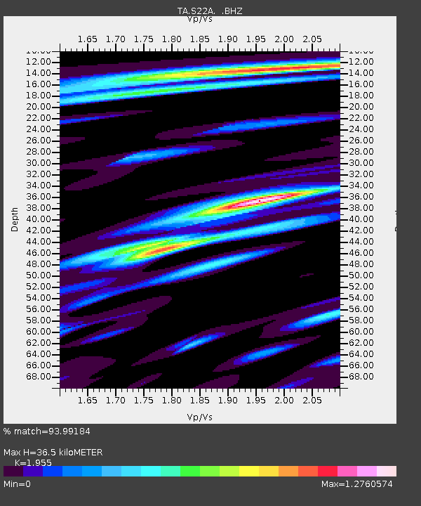
S22A 4UR Ranch, Creede, CO, USA - Earthquake Result Viewer

Earthquake location: Andreanof Islands, Aleutian Is.
Earthquake latitude/longitude: 51.6/-174.8
Earthquake time(UTC): 2013/09/04 (247) 02:32:30 GMT
Earthquake Depth: 20 km
Earthquake Magnitude: 6.5 MWW, 5.9 ML, 6.3 MWB, 6.5 MI, 6.5 MWC, 6.5 MWW
Earthquake Catalog/Contributor: NEIC PDE/NEIC COMCAT
Network: TA USArray Transportable Network (new EarthScope stations)
Station: S22A 4UR Ranch, Creede, CO, USA
Lat/Lon: 37.75 N/106.83 W
Elevation: 2626 m
Distance: 48.5 deg
Az: 78.613 deg
Baz: 309.463 deg
Ray Param: 0.06926735
Estimated Moho Depth: 36.5 km
Estimated Crust Vp/Vs: 1.96
Assumed Crust Vp: 6.159 km/s
Estimated Crust Vs: 3.15 km/s
Estimated Crust Poisson's Ratio: 0.32
Radial Match: 93.99184 %
Radial Bump: 400
Transverse Match: 85.92437 %
Transverse Bump: 400
SOD ConfigId: 626651
Insert Time: 2014-04-18 10:20:15.054 +0000
GWidth: 2.5
Max Bumps: 400
Tol: 0.001

Signal To Noise

ChannelStoNSTALTA
TA:S22A: :BHZ:20130904T02:40:41.399988Z5.61053665.140257E-79.161793E-8
TA:S22A: :BHN:20130904T02:40:41.399988Z2.29592822.1738211E-79.468158E-8
TA:S22A: :BHE:20130904T02:40:41.399988Z2.7275692.5144996E-79.21883E-8
Arrivals
Ps5.9 SECOND
PpPs17 SECOND
PsPs/PpSs23 SECOND