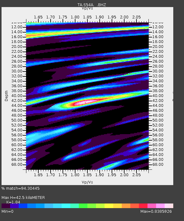
S54A Dingess, Beckley, WV, USA - Earthquake Result Viewer
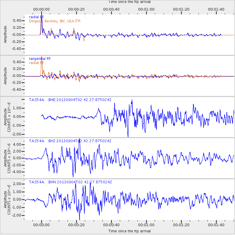
Earthquake location: Andreanof Islands, Aleutian Is.
Earthquake latitude/longitude: 51.6/-174.8
Earthquake time(UTC): 2013/09/04 (247) 02:32:30 GMT
Earthquake Depth: 20 km
Earthquake Magnitude: 6.5 MWW, 5.9 ML, 6.3 MWB, 6.5 MI, 6.5 MWC, 6.5 MWW
Earthquake Catalog/Contributor: NEIC PDE/NEIC COMCAT
Network: TA USArray Transportable Network (new EarthScope stations)
Station: S54A Dingess, Beckley, WV, USA
Lat/Lon: 37.80 N/81.31 W
Elevation: 636 m
Distance: 63.5 deg
Az: 62.119 deg
Baz: 315.844 deg
Ray Param: 0.059547618
Estimated Moho Depth: 42.5 km
Estimated Crust Vp/Vs: 1.84
Assumed Crust Vp: 6.159 km/s
Estimated Crust Vs: 3.347 km/s
Estimated Crust Poisson's Ratio: 0.29
Radial Match: 94.30445 %
Radial Bump: 400
Transverse Match: 80.72291 %
Transverse Bump: 400
SOD ConfigId: 626651
Insert Time: 2014-04-18 10:20:32.522 +0000
GWidth: 2.5
Max Bumps: 400
Tol: 0.001

Signal To Noise

ChannelStoNSTALTA
TA:S54A: :BHZ:20130904T02:42:27.875024Z9.0471181.6085421E-61.7779608E-7
TA:S54A: :BHN:20130904T02:42:27.875024Z5.72629175.1610266E-79.01286E-8
TA:S54A: :BHE:20130904T02:42:27.875024Z4.52153875.134291E-71.1355185E-7
Arrivals
Ps6.0 SECOND
PpPs19 SECOND
PsPs/PpSs25 SECOND