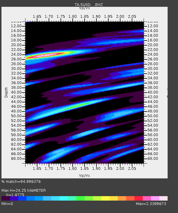
SUSD Miller, SD, USA - Earthquake Result Viewer

Earthquake location: Andreanof Islands, Aleutian Is.
Earthquake latitude/longitude: 51.6/-174.8
Earthquake time(UTC): 2013/09/04 (247) 02:32:30 GMT
Earthquake Depth: 20 km
Earthquake Magnitude: 6.5 MWW, 5.9 ML, 6.3 MWB, 6.5 MI, 6.5 MWC, 6.5 MWW
Earthquake Catalog/Contributor: NEIC PDE/NEIC COMCAT
Network: TA USArray Transportable Network (new EarthScope stations)
Station: SUSD Miller, SD, USA
Lat/Lon: 44.44 N/98.96 W
Elevation: 520 m
Distance: 49.1 deg
Az: 66.742 deg
Baz: 306.8 deg
Ray Param: 0.068892136
Estimated Moho Depth: 24.25 km
Estimated Crust Vp/Vs: 1.68
Assumed Crust Vp: 6.53 km/s
Estimated Crust Vs: 3.893 km/s
Estimated Crust Poisson's Ratio: 0.22
Radial Match: 94.996376 %
Radial Bump: 400
Transverse Match: 89.57052 %
Transverse Bump: 400
SOD ConfigId: 626651
Insert Time: 2014-04-18 10:20:54.766 +0000
GWidth: 2.5
Max Bumps: 400
Tol: 0.001

Signal To Noise

ChannelStoNSTALTA
TA:SUSD: :BHZ:20130904T02:40:45.698999Z7.7957951.3556424E-61.7389407E-7
TA:SUSD: :BHN:20130904T02:40:45.698999Z2.31631786.299489E-72.7196134E-7
TA:SUSD: :BHE:20130904T02:40:45.698999Z4.26677138.3836693E-71.9648743E-7
Arrivals
Ps2.7 SECOND
PpPs9.3 SECOND
PsPs/PpSs12 SECOND