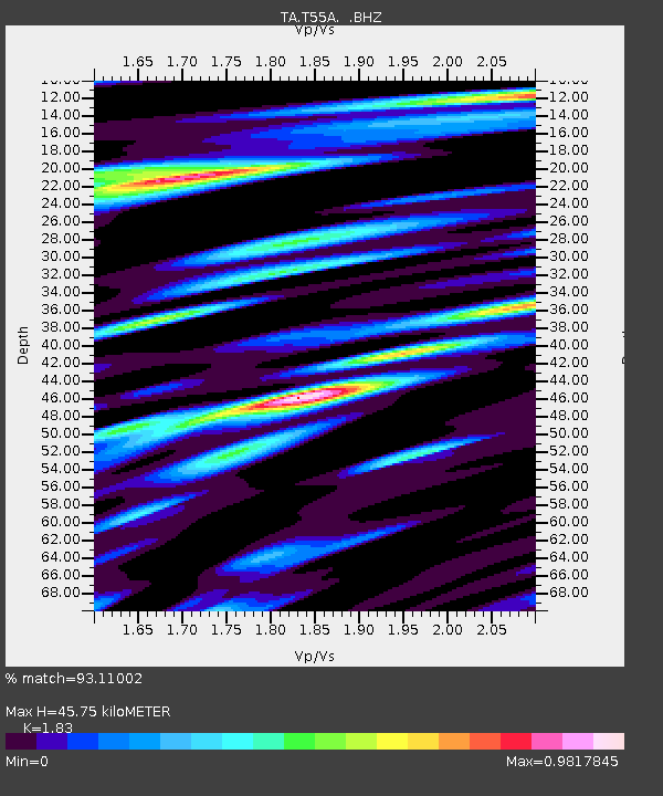
T55A Pulaski, VA, USA - Earthquake Result Viewer

Earthquake location: Andreanof Islands, Aleutian Is.
Earthquake latitude/longitude: 51.6/-174.8
Earthquake time(UTC): 2013/09/04 (247) 02:32:30 GMT
Earthquake Depth: 20 km
Earthquake Magnitude: 6.5 MWW, 5.9 ML, 6.3 MWB, 6.5 MI, 6.5 MWC, 6.5 MWW
Earthquake Catalog/Contributor: NEIC PDE/NEIC COMCAT
Network: TA USArray Transportable Network (new EarthScope stations)
Station: T55A Pulaski, VA, USA
Lat/Lon: 37.12 N/80.78 W
Elevation: 644 m
Distance: 64.2 deg
Az: 62.309 deg
Baz: 316.247 deg
Ray Param: 0.05903279
Estimated Moho Depth: 45.75 km
Estimated Crust Vp/Vs: 1.83
Assumed Crust Vp: 6.159 km/s
Estimated Crust Vs: 3.365 km/s
Estimated Crust Poisson's Ratio: 0.29
Radial Match: 93.11002 %
Radial Bump: 400
Transverse Match: 76.386345 %
Transverse Bump: 400
SOD ConfigId: 626651
Insert Time: 2014-04-18 10:21:14.937 +0000
GWidth: 2.5
Max Bumps: 400
Tol: 0.001

Signal To Noise

ChannelStoNSTALTA
TA:T55A: :BHZ:20130904T02:42:33.000024Z14.2502611.6540047E-61.1606838E-7
TA:T55A: :BHN:20130904T02:42:33.000024Z4.6435975.6832477E-71.223889E-7
TA:T55A: :BHE:20130904T02:42:33.000024Z3.12948544.772632E-71.5250532E-7
Arrivals
Ps6.4 SECOND
PpPs20 SECOND
PsPs/PpSs27 SECOND