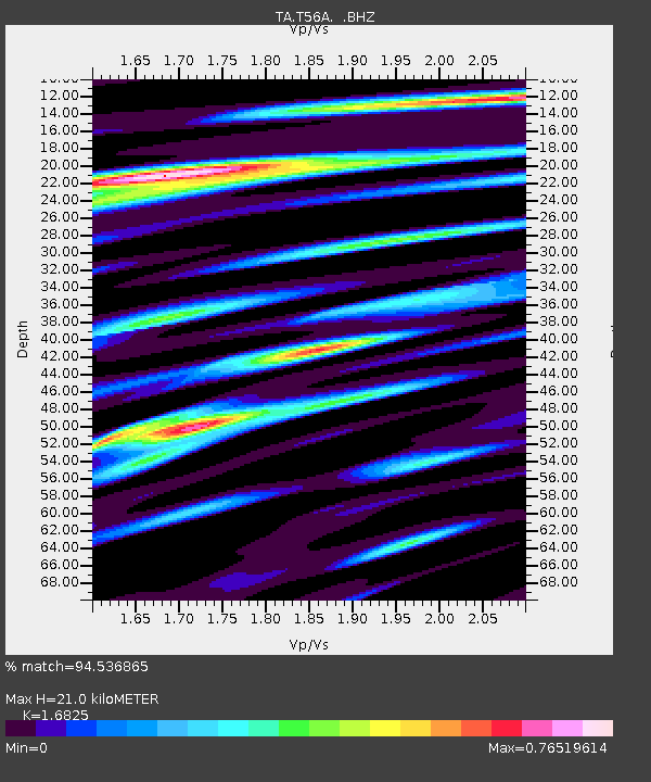
T56A Rocky Mt, VA, USA - Earthquake Result Viewer
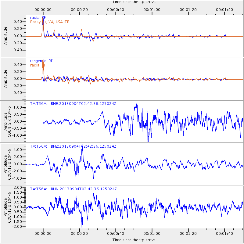
Earthquake location: Andreanof Islands, Aleutian Is.
Earthquake latitude/longitude: 51.6/-174.8
Earthquake time(UTC): 2013/09/04 (247) 02:32:30 GMT
Earthquake Depth: 20 km
Earthquake Magnitude: 6.5 MWW, 5.9 ML, 6.3 MWB, 6.5 MI, 6.5 MWC, 6.5 MWW
Earthquake Catalog/Contributor: NEIC PDE/NEIC COMCAT
Network: TA USArray Transportable Network (new EarthScope stations)
Station: T56A Rocky Mt, VA, USA
Lat/Lon: 37.03 N/80.03 W
Elevation: 387 m
Distance: 64.7 deg
Az: 61.893 deg
Baz: 316.52 deg
Ray Param: 0.058726136
Estimated Moho Depth: 21.0 km
Estimated Crust Vp/Vs: 1.68
Assumed Crust Vp: 6.159 km/s
Estimated Crust Vs: 3.66 km/s
Estimated Crust Poisson's Ratio: 0.23
Radial Match: 94.536865 %
Radial Bump: 400
Transverse Match: 78.12991 %
Transverse Bump: 400
SOD ConfigId: 626651
Insert Time: 2014-04-18 10:21:17.443 +0000
GWidth: 2.5
Max Bumps: 400
Tol: 0.001

Signal To Noise

ChannelStoNSTALTA
TA:T56A: :BHZ:20130904T02:42:36.125024Z7.64220861.2326873E-61.6129987E-7
TA:T56A: :BHN:20130904T02:42:36.125024Z3.81513673.840715E-71.0067045E-7
TA:T56A: :BHE:20130904T02:42:36.125024Z4.03948073.7348363E-79.245833E-8
Arrivals
Ps2.4 SECOND
PpPs8.8 SECOND
PsPs/PpSs11 SECOND