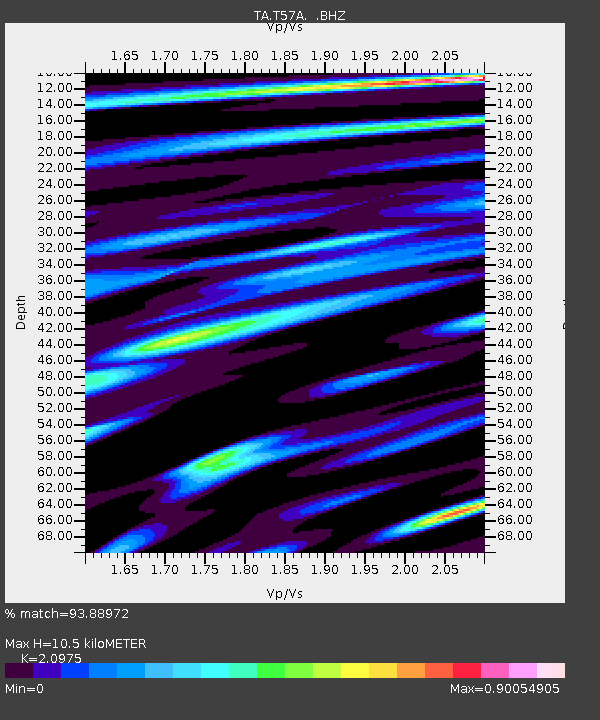
T57A Hurt, VA, USA - Earthquake Result Viewer
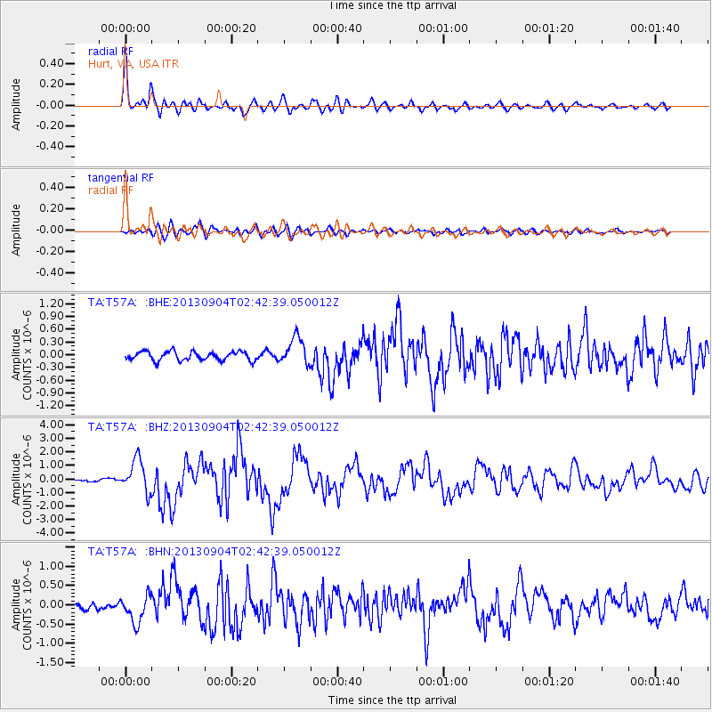
Earthquake location: Andreanof Islands, Aleutian Is.
Earthquake latitude/longitude: 51.6/-174.8
Earthquake time(UTC): 2013/09/04 (247) 02:32:30 GMT
Earthquake Depth: 20 km
Earthquake Magnitude: 6.5 MWW, 5.9 ML, 6.3 MWB, 6.5 MI, 6.5 MWC, 6.5 MWW
Earthquake Catalog/Contributor: NEIC PDE/NEIC COMCAT
Network: TA USArray Transportable Network (new EarthScope stations)
Station: T57A Hurt, VA, USA
Lat/Lon: 37.00 N/79.25 W
Elevation: 230 m
Distance: 65.2 deg
Az: 61.417 deg
Baz: 316.784 deg
Ray Param: 0.058432825
Estimated Moho Depth: 10.5 km
Estimated Crust Vp/Vs: 2.10
Assumed Crust Vp: 6.419 km/s
Estimated Crust Vs: 3.06 km/s
Estimated Crust Poisson's Ratio: 0.35
Radial Match: 93.88972 %
Radial Bump: 400
Transverse Match: 81.68865 %
Transverse Bump: 400
SOD ConfigId: 626651
Insert Time: 2014-04-18 10:21:19.777 +0000
GWidth: 2.5
Max Bumps: 400
Tol: 0.001

Signal To Noise

ChannelStoNSTALTA
TA:T57A: :BHZ:20130904T02:42:39.050012Z9.7119391.2269322E-61.2633237E-7
TA:T57A: :BHN:20130904T02:42:39.050012Z3.91919023.5763247E-79.125162E-8
TA:T57A: :BHE:20130904T02:42:39.050012Z3.17991283.2706578E-71.028537E-7
Arrivals
Ps1.9 SECOND
PpPs4.9 SECOND
PsPs/PpSs6.8 SECOND