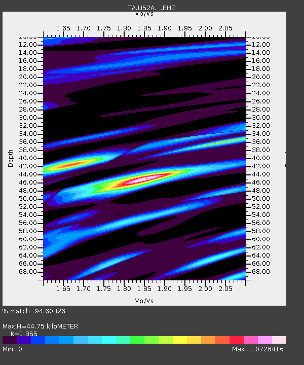
U52A Thorn Hill, TN, USA - Earthquake Result Viewer

Earthquake location: Andreanof Islands, Aleutian Is.
Earthquake latitude/longitude: 51.6/-174.8
Earthquake time(UTC): 2013/09/04 (247) 02:32:30 GMT
Earthquake Depth: 20 km
Earthquake Magnitude: 6.5 MWW, 5.9 ML, 6.3 MWB, 6.5 MI, 6.5 MWC, 6.5 MWW
Earthquake Catalog/Contributor: NEIC PDE/NEIC COMCAT
Network: TA USArray Transportable Network (new EarthScope stations)
Station: U52A Thorn Hill, TN, USA
Lat/Lon: 36.39 N/83.37 W
Elevation: 510 m
Distance: 63.3 deg
Az: 64.532 deg
Baz: 315.69 deg
Ray Param: 0.059638638
Estimated Moho Depth: 44.75 km
Estimated Crust Vp/Vs: 1.86
Assumed Crust Vp: 6.476 km/s
Estimated Crust Vs: 3.491 km/s
Estimated Crust Poisson's Ratio: 0.30
Radial Match: 94.60826 %
Radial Bump: 400
Transverse Match: 75.279724 %
Transverse Bump: 400
SOD ConfigId: 626651
Insert Time: 2014-04-18 10:21:44.178 +0000
GWidth: 2.5
Max Bumps: 400
Tol: 0.001

Signal To Noise

ChannelStoNSTALTA
TA:U52A: :BHZ:20130904T02:42:26.949976Z9.8884581.0828386E-61.0950531E-7
TA:U52A: :BHN:20130904T02:42:26.949976Z3.92640264.0264112E-71.02547084E-7
TA:U52A: :BHE:20130904T02:42:26.949976Z3.41189553.5158698E-71.030474E-7
Arrivals
Ps6.2 SECOND
PpPs19 SECOND
PsPs/PpSs25 SECOND