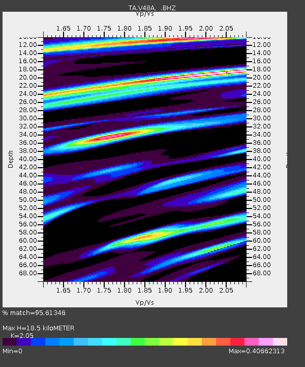
V48A Smith Brothers Farm, Spring Hill, TN, USA - Earthquake Result Viewer
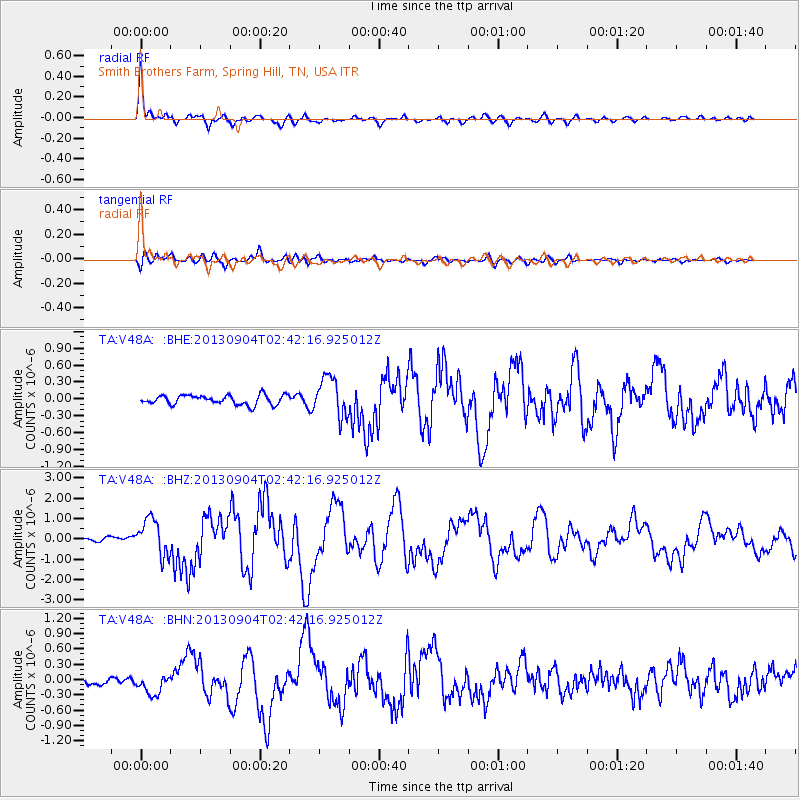
Earthquake location: Andreanof Islands, Aleutian Is.
Earthquake latitude/longitude: 51.6/-174.8
Earthquake time(UTC): 2013/09/04 (247) 02:32:30 GMT
Earthquake Depth: 20 km
Earthquake Magnitude: 6.5 MWW, 5.9 ML, 6.3 MWB, 6.5 MI, 6.5 MWC, 6.5 MWW
Earthquake Catalog/Contributor: NEIC PDE/NEIC COMCAT
Network: TA USArray Transportable Network (new EarthScope stations)
Station: V48A Smith Brothers Farm, Spring Hill, TN, USA
Lat/Lon: 35.74 N/86.82 W
Elevation: 278 m
Distance: 61.8 deg
Az: 67.29 deg
Baz: 314.936 deg
Ray Param: 0.06061977
Estimated Moho Depth: 18.5 km
Estimated Crust Vp/Vs: 2.05
Assumed Crust Vp: 6.476 km/s
Estimated Crust Vs: 3.159 km/s
Estimated Crust Poisson's Ratio: 0.34
Radial Match: 95.61346 %
Radial Bump: 400
Transverse Match: 75.269264 %
Transverse Bump: 400
SOD ConfigId: 626651
Insert Time: 2014-04-18 10:22:07.908 +0000
GWidth: 2.5
Max Bumps: 400
Tol: 0.001

Signal To Noise

ChannelStoNSTALTA
TA:V48A: :BHZ:20130904T02:42:16.925012Z9.8332319.0401795E-79.1934986E-8
TA:V48A: :BHN:20130904T02:42:16.925012Z3.18199561.984169E-76.235612E-8
TA:V48A: :BHE:20130904T02:42:16.925012Z4.15168333.4850336E-78.3942666E-8
Arrivals
Ps3.1 SECOND
PpPs8.4 SECOND
PsPs/PpSs11 SECOND