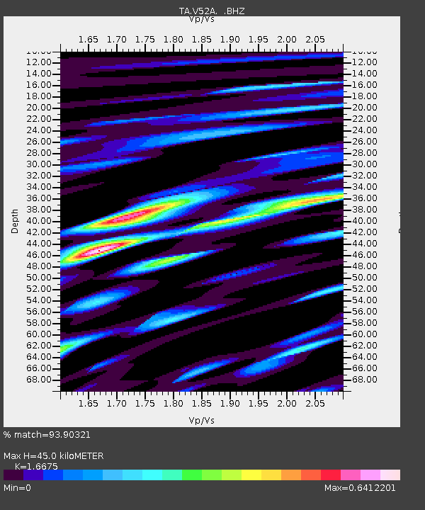
V52A Sevierville, TN, USA - Earthquake Result Viewer

Earthquake location: Andreanof Islands, Aleutian Is.
Earthquake latitude/longitude: 51.6/-174.8
Earthquake time(UTC): 2013/09/04 (247) 02:32:30 GMT
Earthquake Depth: 20 km
Earthquake Magnitude: 6.5 MWW, 5.9 ML, 6.3 MWB, 6.5 MI, 6.5 MWC, 6.5 MWW
Earthquake Catalog/Contributor: NEIC PDE/NEIC COMCAT
Network: TA USArray Transportable Network (new EarthScope stations)
Station: V52A Sevierville, TN, USA
Lat/Lon: 35.84 N/83.60 W
Elevation: 328 m
Distance: 63.6 deg
Az: 65.109 deg
Baz: 315.814 deg
Ray Param: 0.05946727
Estimated Moho Depth: 45.0 km
Estimated Crust Vp/Vs: 1.67
Assumed Crust Vp: 6.35 km/s
Estimated Crust Vs: 3.808 km/s
Estimated Crust Poisson's Ratio: 0.22
Radial Match: 93.90321 %
Radial Bump: 400
Transverse Match: 72.26076 %
Transverse Bump: 400
SOD ConfigId: 626651
Insert Time: 2014-04-18 10:22:16.719 +0000
GWidth: 2.5
Max Bumps: 400
Tol: 0.001

Signal To Noise

ChannelStoNSTALTA
TA:V52A: :BHZ:20130904T02:42:28.699976Z11.0025251.227213E-61.11539215E-7
TA:V52A: :BHN:20130904T02:42:28.699976Z5.3515144.3258572E-78.083427E-8
TA:V52A: :BHE:20130904T02:42:28.699976Z2.55509262.6679362E-71.04416415E-7
Arrivals
Ps4.9 SECOND
PpPs18 SECOND
PsPs/PpSs23 SECOND