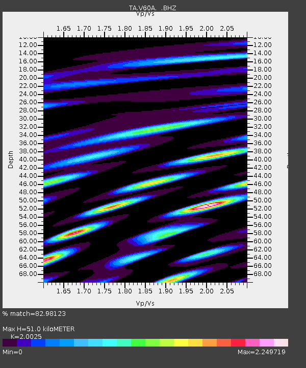
V60A Jim Taylor Road, Stokes, NC, USA - Earthquake Result Viewer

Earthquake location: Andreanof Islands, Aleutian Is.
Earthquake latitude/longitude: 51.6/-174.8
Earthquake time(UTC): 2013/09/04 (247) 02:32:30 GMT
Earthquake Depth: 20 km
Earthquake Magnitude: 6.5 MWW, 5.9 ML, 6.3 MWB, 6.5 MI, 6.5 MWC, 6.5 MWW
Earthquake Catalog/Contributor: NEIC PDE/NEIC COMCAT
Network: TA USArray Transportable Network (new EarthScope stations)
Station: V60A Jim Taylor Road, Stokes, NC, USA
Lat/Lon: 35.76 N/77.26 W
Elevation: 8.0 m
Distance: 67.2 deg
Az: 61.039 deg
Baz: 317.807 deg
Ray Param: 0.057120606
Estimated Moho Depth: 51.0 km
Estimated Crust Vp/Vs: 2.00
Assumed Crust Vp: 6.565 km/s
Estimated Crust Vs: 3.278 km/s
Estimated Crust Poisson's Ratio: 0.33
Radial Match: 82.98123 %
Radial Bump: 400
Transverse Match: 52.790413 %
Transverse Bump: 400
SOD ConfigId: 626651
Insert Time: 2014-04-18 10:22:35.625 +0000
GWidth: 2.5
Max Bumps: 400
Tol: 0.001

Signal To Noise

ChannelStoNSTALTA
TA:V60A: :BHZ:20130904T02:42:51.824976Z9.0078331.26258E-61.4016469E-7
TA:V60A: :BHN:20130904T02:42:51.824976Z1.11118735.2226346E-74.700049E-7
TA:V60A: :BHE:20130904T02:42:51.824976Z1.64342715.6259086E-73.4232784E-7
Arrivals
Ps8.1 SECOND
PpPs22 SECOND
PsPs/PpSs31 SECOND