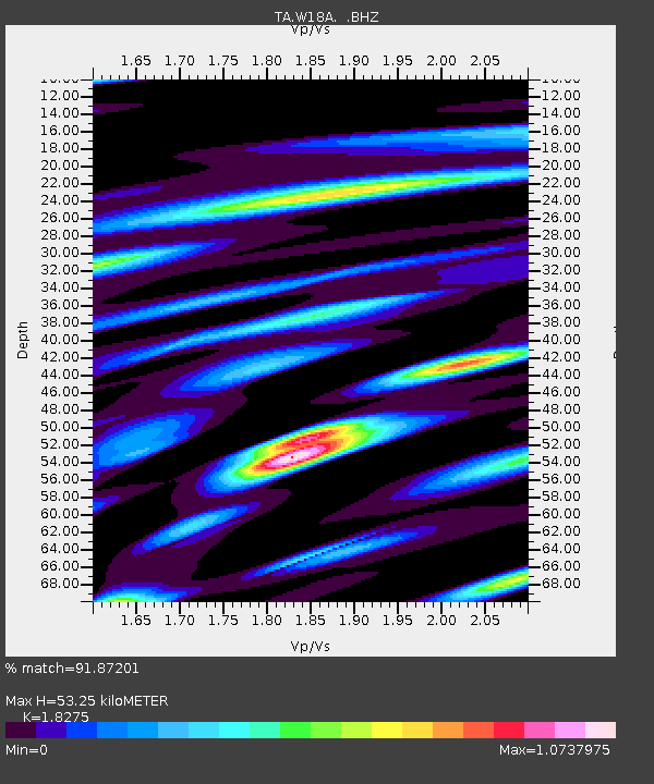
W18A Petrified Forest, AZ, USA - Earthquake Result Viewer

Earthquake location: Andreanof Islands, Aleutian Is.
Earthquake latitude/longitude: 51.6/-174.8
Earthquake time(UTC): 2013/09/04 (247) 02:32:30 GMT
Earthquake Depth: 20 km
Earthquake Magnitude: 6.5 MWW, 5.9 ML, 6.3 MWB, 6.5 MI, 6.5 MWC, 6.5 MWW
Earthquake Catalog/Contributor: NEIC PDE/NEIC COMCAT
Network: TA USArray Transportable Network (new EarthScope stations)
Station: W18A Petrified Forest, AZ, USA
Lat/Lon: 35.12 N/109.74 W
Elevation: 1750 m
Distance: 48.4 deg
Az: 83.308 deg
Baz: 310.857 deg
Ray Param: 0.0693345
Estimated Moho Depth: 53.25 km
Estimated Crust Vp/Vs: 1.83
Assumed Crust Vp: 6.496 km/s
Estimated Crust Vs: 3.555 km/s
Estimated Crust Poisson's Ratio: 0.29
Radial Match: 91.87201 %
Radial Bump: 400
Transverse Match: 70.331375 %
Transverse Bump: 400
SOD ConfigId: 626651
Insert Time: 2014-04-18 10:22:42.063 +0000
GWidth: 2.5
Max Bumps: 400
Tol: 0.001

Signal To Noise

ChannelStoNSTALTA
TA:W18A: :BHZ:20130904T02:40:40.624994Z5.4429153.7690054E-76.9246084E-8
TA:W18A: :BHN:20130904T02:40:40.624994Z1.26769051.4200623E-71.12019634E-7
TA:W18A: :BHE:20130904T02:40:40.624994Z1.62651351.9501721E-71.1989891E-7
Arrivals
Ps7.2 SECOND
PpPs22 SECOND
PsPs/PpSs29 SECOND