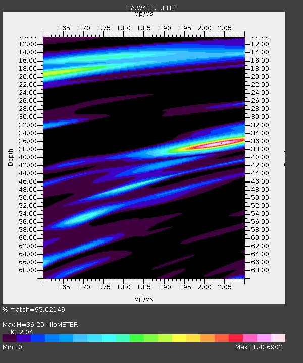
W41B Gary Mavity, Velonia, AR, USA - Earthquake Result Viewer
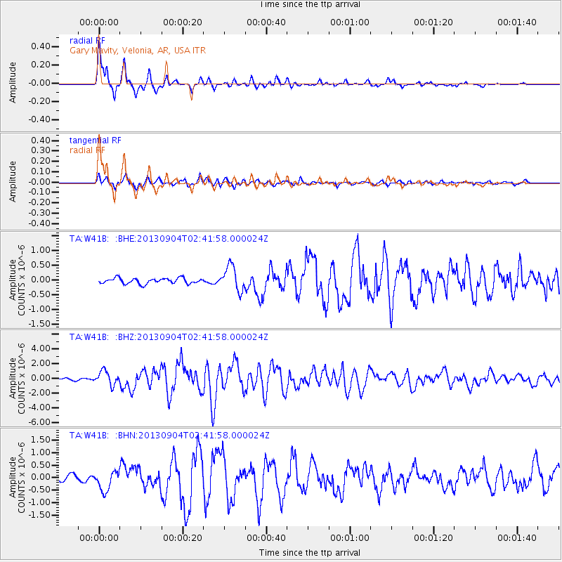
Earthquake location: Andreanof Islands, Aleutian Is.
Earthquake latitude/longitude: 51.6/-174.8
Earthquake time(UTC): 2013/09/04 (247) 02:32:30 GMT
Earthquake Depth: 20 km
Earthquake Magnitude: 6.5 MWW, 5.9 ML, 6.3 MWB, 6.5 MI, 6.5 MWC, 6.5 MWW
Earthquake Catalog/Contributor: NEIC PDE/NEIC COMCAT
Network: TA USArray Transportable Network (new EarthScope stations)
Station: W41B Gary Mavity, Velonia, AR, USA
Lat/Lon: 35.17 N/92.25 W
Elevation: 95 m
Distance: 59.0 deg
Az: 71.315 deg
Baz: 313.789 deg
Ray Param: 0.062434595
Estimated Moho Depth: 36.25 km
Estimated Crust Vp/Vs: 2.04
Assumed Crust Vp: 6.498 km/s
Estimated Crust Vs: 3.185 km/s
Estimated Crust Poisson's Ratio: 0.34
Radial Match: 95.02149 %
Radial Bump: 400
Transverse Match: 82.04719 %
Transverse Bump: 400
SOD ConfigId: 626651
Insert Time: 2014-04-18 10:22:46.740 +0000
GWidth: 2.5
Max Bumps: 400
Tol: 0.001

Signal To Noise

ChannelStoNSTALTA
TA:W41B: :BHZ:20130904T02:41:58.000024Z6.5476349.575662E-71.4624614E-7
TA:W41B: :BHN:20130904T02:41:58.000024Z3.4709784.0462203E-71.1657291E-7
TA:W41B: :BHE:20130904T02:41:58.000024Z4.68597564.312873E-79.2037894E-8
Arrivals
Ps6.1 SECOND
PpPs16 SECOND
PsPs/PpSs22 SECOND