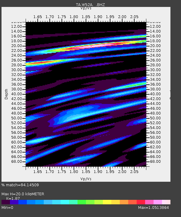
W52A Murphy, NC, USA - Earthquake Result Viewer
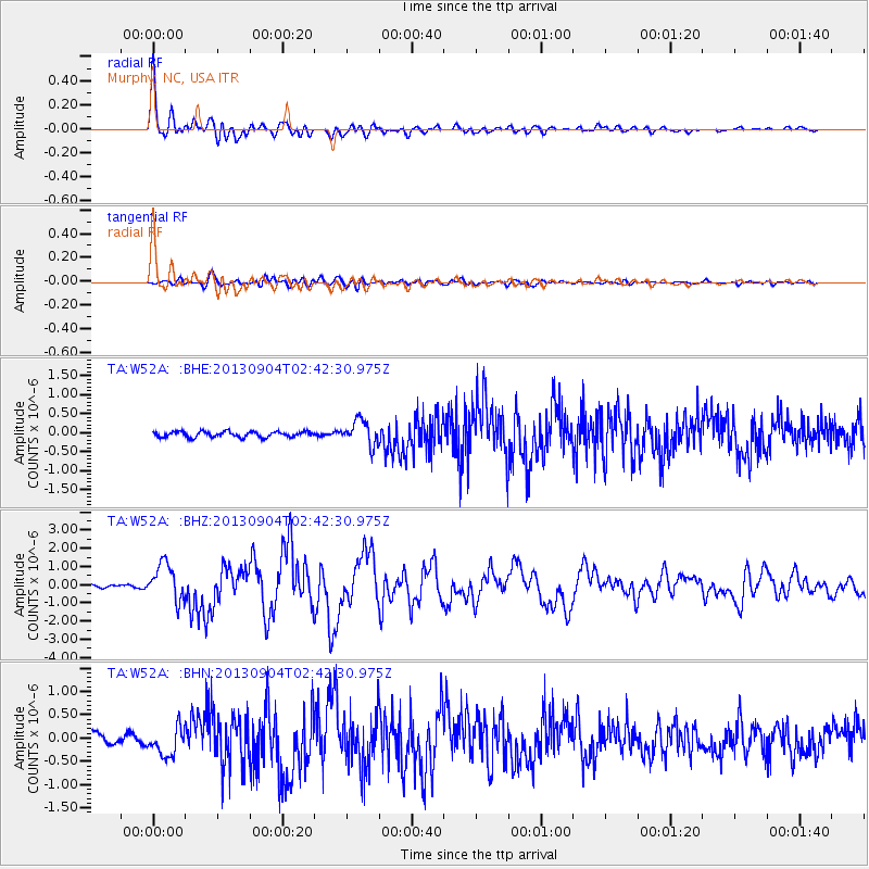
Earthquake location: Andreanof Islands, Aleutian Is.
Earthquake latitude/longitude: 51.6/-174.8
Earthquake time(UTC): 2013/09/04 (247) 02:32:30 GMT
Earthquake Depth: 20 km
Earthquake Magnitude: 6.5 MWW, 5.9 ML, 6.3 MWB, 6.5 MI, 6.5 MWC, 6.5 MWW
Earthquake Catalog/Contributor: NEIC PDE/NEIC COMCAT
Network: TA USArray Transportable Network (new EarthScope stations)
Station: W52A Murphy, NC, USA
Lat/Lon: 35.09 N/83.93 W
Elevation: 519 m
Distance: 63.9 deg
Az: 65.905 deg
Baz: 315.975 deg
Ray Param: 0.059238236
Estimated Moho Depth: 20.0 km
Estimated Crust Vp/Vs: 1.87
Assumed Crust Vp: 6.35 km/s
Estimated Crust Vs: 3.396 km/s
Estimated Crust Poisson's Ratio: 0.30
Radial Match: 94.14509 %
Radial Bump: 400
Transverse Match: 81.261 %
Transverse Bump: 400
SOD ConfigId: 626651
Insert Time: 2014-04-18 10:22:56.215 +0000
GWidth: 2.5
Max Bumps: 400
Tol: 0.001

Signal To Noise

ChannelStoNSTALTA
TA:W52A: :BHZ:20130904T02:42:30.975Z8.2547051.0167445E-61.231715E-7
TA:W52A: :BHN:20130904T02:42:30.975Z3.01152753.0127356E-71.0004011E-7
TA:W52A: :BHE:20130904T02:42:30.975Z4.3903863.2356172E-77.3697784E-8
Arrivals
Ps2.9 SECOND
PpPs8.7 SECOND
PsPs/PpSs12 SECOND