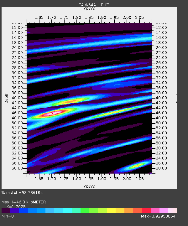
W54A Cherokee Point, Campobello, SC, USA - Earthquake Result Viewer

Earthquake location: Andreanof Islands, Aleutian Is.
Earthquake latitude/longitude: 51.6/-174.8
Earthquake time(UTC): 2013/09/04 (247) 02:32:30 GMT
Earthquake Depth: 20 km
Earthquake Magnitude: 6.5 MWW, 5.9 ML, 6.3 MWB, 6.5 MI, 6.5 MWC, 6.5 MWW
Earthquake Catalog/Contributor: NEIC PDE/NEIC COMCAT
Network: TA USArray Transportable Network (new EarthScope stations)
Station: W54A Cherokee Point, Campobello, SC, USA
Lat/Lon: 35.09 N/82.19 W
Elevation: 272 m
Distance: 64.9 deg
Az: 64.768 deg
Baz: 316.48 deg
Ray Param: 0.058593504
Estimated Moho Depth: 46.0 km
Estimated Crust Vp/Vs: 1.70
Assumed Crust Vp: 6.35 km/s
Estimated Crust Vs: 3.73 km/s
Estimated Crust Poisson's Ratio: 0.24
Radial Match: 93.786194 %
Radial Bump: 400
Transverse Match: 70.458595 %
Transverse Bump: 400
SOD ConfigId: 626651
Insert Time: 2014-04-18 10:23:00.738 +0000
GWidth: 2.5
Max Bumps: 400
Tol: 0.001

Signal To Noise

ChannelStoNSTALTA
TA:W54A: :BHZ:20130904T02:42:37.475Z11.2141881.0661836E-69.5074526E-8
TA:W54A: :BHN:20130904T02:42:37.475Z4.18273163.7857103E-79.050809E-8
TA:W54A: :BHE:20130904T02:42:37.475Z3.05274342.652219E-78.687985E-8
Arrivals
Ps5.3 SECOND
PpPs19 SECOND
PsPs/PpSs24 SECOND