W57A Gilead, NC, USA - Earthquake Result Viewer
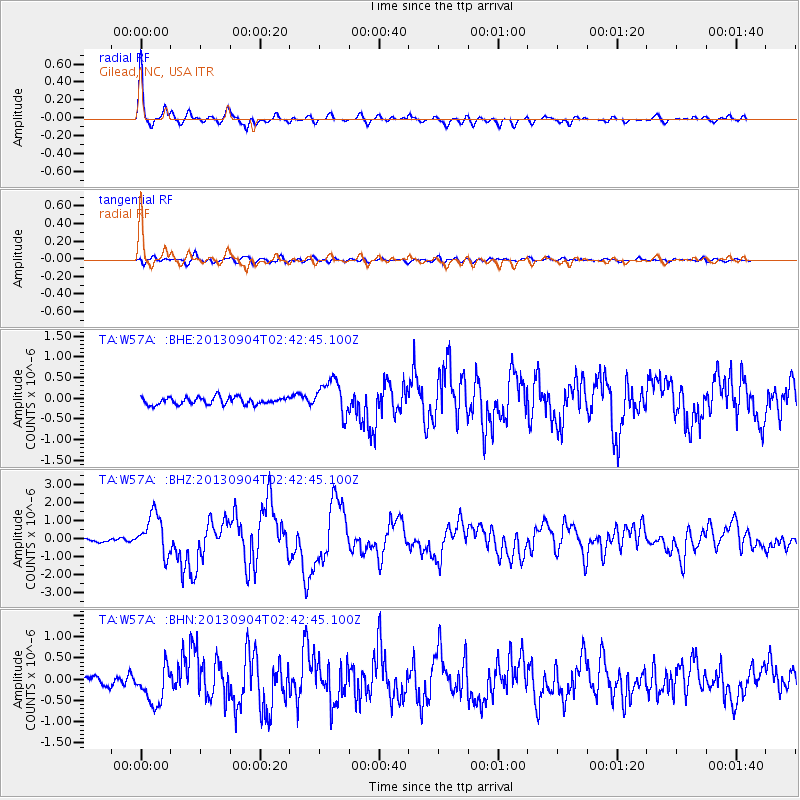
Earthquake location: Andreanof Islands, Aleutian Is.
Earthquake latitude/longitude: 51.6/-174.8
Earthquake time(UTC): 2013/09/04 (247) 02:32:30 GMT
Earthquake Depth: 20 km
Earthquake Magnitude: 6.5 MWW, 5.9 ML, 6.3 MWB, 6.5 MI, 6.5 MWC, 6.5 MWW
Earthquake Catalog/Contributor: NEIC PDE/NEIC COMCAT
Network: TA USArray Transportable Network (new EarthScope stations)
Station: W57A Gilead, NC, USA
Lat/Lon: 35.15 N/79.99 W
Elevation: 85 m
Distance: 66.1 deg
Az: 63.277 deg
Baz: 317.118 deg
Ray Param: 0.05781808
Estimated Moho Depth: 34.0 km
Estimated Crust Vp/Vs: 1.93
Assumed Crust Vp: 6.565 km/s
Estimated Crust Vs: 3.401 km/s
Estimated Crust Poisson's Ratio: 0.32
Radial Match: 91.98366 %
Radial Bump: 353
Transverse Match: 69.50817 %
Transverse Bump: 400
SOD ConfigId: 626651
Insert Time: 2014-04-18 10:23:04.944 +0000
GWidth: 2.5
Max Bumps: 400
Tol: 0.001

Signal To Noise

ChannelStoNSTALTA
TA:W57A: :BHZ:20130904T02:42:45.100Z9.1124421.1107804E-61.2189712E-7
TA:W57A: :BHN:20130904T02:42:45.100Z3.26734644.693712E-71.4365517E-7
TA:W57A: :BHE:20130904T02:42:45.100Z4.7489434.1372675E-78.711976E-8
Arrivals
Ps5.0 SECOND
PpPs15 SECOND
PsPs/PpSs20 SECOND