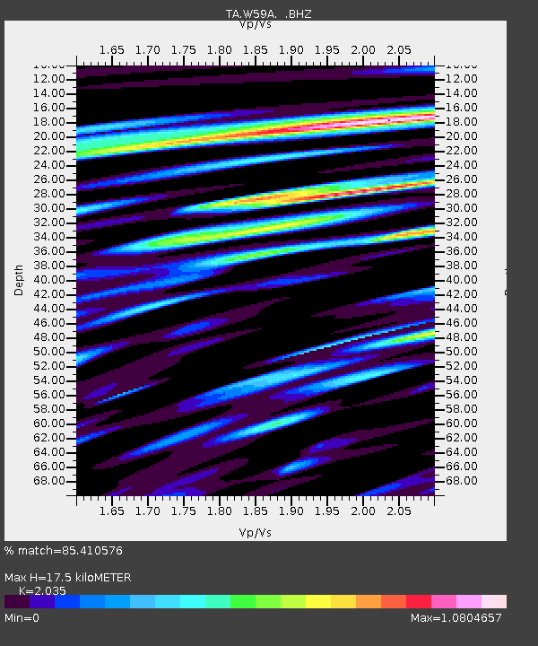
W59A Clinton, NC, USA - Earthquake Result Viewer

Earthquake location: Andreanof Islands, Aleutian Is.
Earthquake latitude/longitude: 51.6/-174.8
Earthquake time(UTC): 2013/09/04 (247) 02:32:30 GMT
Earthquake Depth: 20 km
Earthquake Magnitude: 6.5 MWW, 5.9 ML, 6.3 MWB, 6.5 MI, 6.5 MWC, 6.5 MWW
Earthquake Catalog/Contributor: NEIC PDE/NEIC COMCAT
Network: TA USArray Transportable Network (new EarthScope stations)
Station: W59A Clinton, NC, USA
Lat/Lon: 35.17 N/78.44 W
Elevation: 60 m
Distance: 66.9 deg
Az: 62.248 deg
Baz: 317.597 deg
Ray Param: 0.057256497
Estimated Moho Depth: 17.5 km
Estimated Crust Vp/Vs: 2.04
Assumed Crust Vp: 6.565 km/s
Estimated Crust Vs: 3.226 km/s
Estimated Crust Poisson's Ratio: 0.34
Radial Match: 85.410576 %
Radial Bump: 400
Transverse Match: 55.139202 %
Transverse Bump: 400
SOD ConfigId: 626651
Insert Time: 2014-04-18 10:23:09.481 +0000
GWidth: 2.5
Max Bumps: 400
Tol: 0.001

Signal To Noise

ChannelStoNSTALTA
TA:W59A: :BHZ:20130904T02:42:50.500024Z9.7545251.2066914E-61.237058E-7
TA:W59A: :BHN:20130904T02:42:50.500024Z3.51070575.8150033E-71.6563631E-7
TA:W59A: :BHE:20130904T02:42:50.500024Z3.18186334.7104533E-71.4804071E-7
Arrivals
Ps2.9 SECOND
PpPs7.8 SECOND
PsPs/PpSs11 SECOND