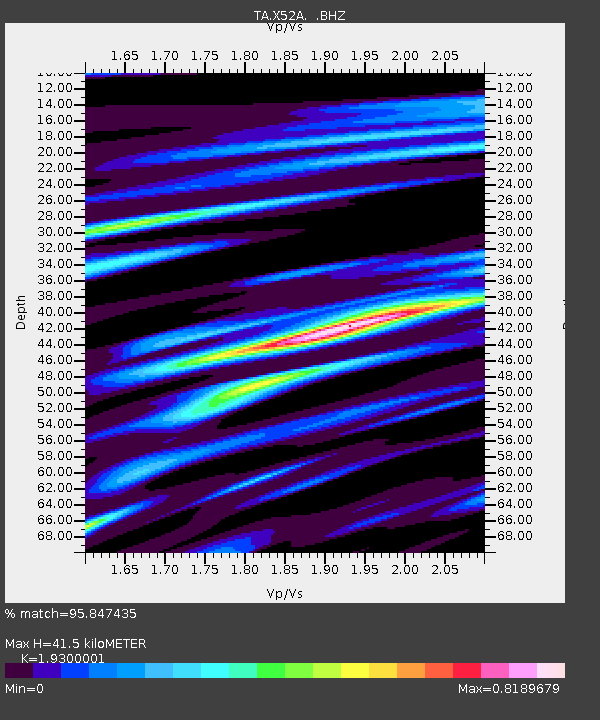
X52A Dahlonega, GA, USA - Earthquake Result Viewer

Earthquake location: Andreanof Islands, Aleutian Is.
Earthquake latitude/longitude: 51.6/-174.8
Earthquake time(UTC): 2013/09/04 (247) 02:32:30 GMT
Earthquake Depth: 20 km
Earthquake Magnitude: 6.5 MWW, 5.9 ML, 6.3 MWB, 6.5 MI, 6.5 MWC, 6.5 MWW
Earthquake Catalog/Contributor: NEIC PDE/NEIC COMCAT
Network: TA USArray Transportable Network (new EarthScope stations)
Station: X52A Dahlonega, GA, USA
Lat/Lon: 34.60 N/83.89 W
Elevation: 481 m
Distance: 64.3 deg
Az: 66.26 deg
Baz: 316.149 deg
Ray Param: 0.05899341
Estimated Moho Depth: 41.5 km
Estimated Crust Vp/Vs: 1.93
Assumed Crust Vp: 6.35 km/s
Estimated Crust Vs: 3.29 km/s
Estimated Crust Poisson's Ratio: 0.32
Radial Match: 95.847435 %
Radial Bump: 392
Transverse Match: 82.3707 %
Transverse Bump: 400
SOD ConfigId: 626651
Insert Time: 2014-04-18 10:23:28.072 +0000
GWidth: 2.5
Max Bumps: 400
Tol: 0.001

Signal To Noise

ChannelStoNSTALTA
TA:X52A: :BHZ:20130904T02:42:33.399988Z7.2666391.0128138E-61.3937857E-7
TA:X52A: :BHN:20130904T02:42:33.399988Z4.0548673.7438141E-79.2328904E-8
TA:X52A: :BHE:20130904T02:42:33.399988Z4.30478763.572676E-78.299309E-8
Arrivals
Ps6.3 SECOND
PpPs18 SECOND
PsPs/PpSs25 SECOND