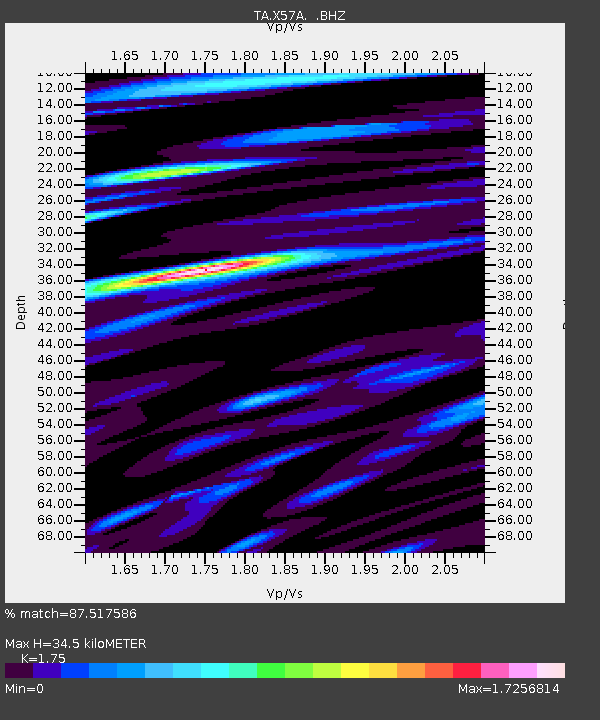
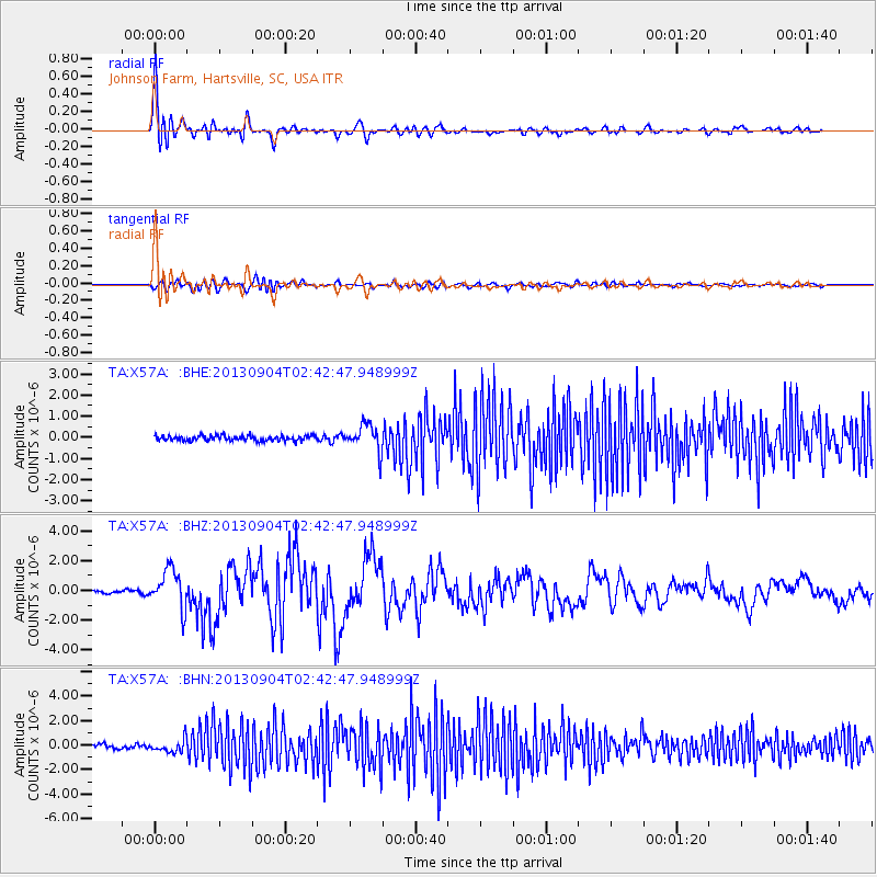
X57A Johnson Farm, Hartsville, SC, USA - Earthquake Result Viewer

Earthquake location: Andreanof Islands, Aleutian Is.
Earthquake latitude/longitude: 51.6/-174.8
Earthquake time(UTC): 2013/09/04 (247) 02:32:30 GMT
Earthquake Depth: 20 km
Earthquake Magnitude: 6.5 MWW, 5.9 ML, 6.3 MWB, 6.5 MI, 6.5 MWC, 6.5 MWW
Earthquake Catalog/Contributor: NEIC PDE/NEIC COMCAT
Network: TA USArray Transportable Network (new EarthScope stations)
Station: X57A Johnson Farm, Hartsville, SC, USA
Lat/Lon: 34.46 N/80.09 W
Elevation: 133 m
Distance: 66.5 deg
Az: 63.854 deg
Baz: 317.292 deg
Ray Param: 0.05752443
Estimated Moho Depth: 34.5 km
Estimated Crust Vp/Vs: 1.75
Assumed Crust Vp: 6.419 km/s
Estimated Crust Vs: 3.668 km/s
Estimated Crust Poisson's Ratio: 0.26
Radial Match: 87.517586 %
Radial Bump: 400
Transverse Match: 62.374294 %
Transverse Bump: 400
SOD ConfigId: 626651
Insert Time: 2014-04-18 10:23:39.409 +0000
GWidth: 2.5
Max Bumps: 400
Tol: 0.001

Signal To Noise

ChannelStoNSTALTA
TA:X57A: :BHZ:20130904T02:42:47.948999Z13.1219781.2964351E-69.879876E-8
TA:X57A: :BHN:20130904T02:42:47.948999Z4.0448775.280288E-71.3054262E-7
TA:X57A: :BHE:20130904T02:42:47.948999Z5.14615256.288539E-71.2219884E-7
Arrivals
Ps4.2 SECOND
PpPs14 SECOND
PsPs/PpSs18 SECOND