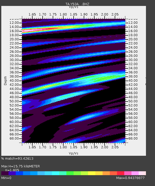
Y53A Monroe, GA, USA - Earthquake Result Viewer
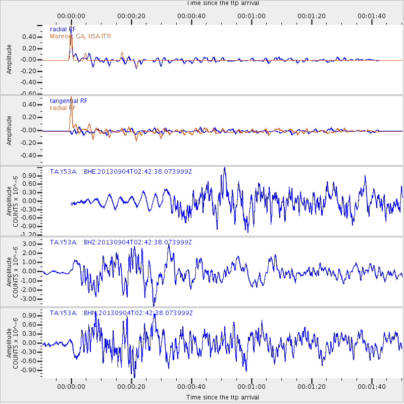
Earthquake location: Andreanof Islands, Aleutian Is.
Earthquake latitude/longitude: 51.6/-174.8
Earthquake time(UTC): 2013/09/04 (247) 02:32:30 GMT
Earthquake Depth: 20 km
Earthquake Magnitude: 6.5 MWW, 5.9 ML, 6.3 MWB, 6.5 MI, 6.5 MWC, 6.5 MWW
Earthquake Catalog/Contributor: NEIC PDE/NEIC COMCAT
Network: TA USArray Transportable Network (new EarthScope stations)
Station: Y53A Monroe, GA, USA
Lat/Lon: 33.86 N/83.58 W
Elevation: 234 m
Distance: 65.0 deg
Az: 66.625 deg
Baz: 316.479 deg
Ray Param: 0.05853132
Estimated Moho Depth: 15.75 km
Estimated Crust Vp/Vs: 1.61
Assumed Crust Vp: 6.565 km/s
Estimated Crust Vs: 4.09 km/s
Estimated Crust Poisson's Ratio: 0.18
Radial Match: 93.42613 %
Radial Bump: 400
Transverse Match: 74.27328 %
Transverse Bump: 400
SOD ConfigId: 626651
Insert Time: 2014-04-18 10:23:59.936 +0000
GWidth: 2.5
Max Bumps: 400
Tol: 0.001

Signal To Noise

ChannelStoNSTALTA
TA:Y53A: :BHZ:20130904T02:42:38.073999Z8.3610438.5894965E-71.0273236E-7
TA:Y53A: :BHN:20130904T02:42:38.073999Z4.14677522.935324E-77.07857E-8
TA:Y53A: :BHE:20130904T02:42:38.073999Z2.08977822.646096E-71.2662092E-7
Arrivals
Ps1.5 SECOND
PpPs6.0 SECOND
PsPs/PpSs7.5 SECOND