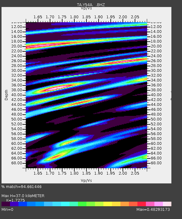
Y54A Tignall, GA, USA - Earthquake Result Viewer
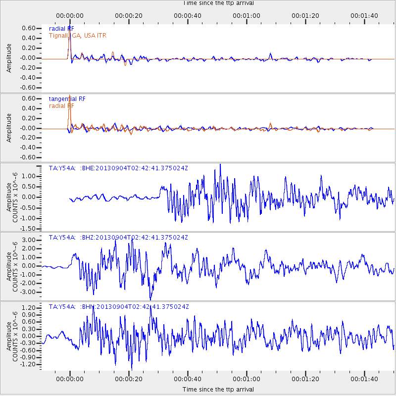
Earthquake location: Andreanof Islands, Aleutian Is.
Earthquake latitude/longitude: 51.6/-174.8
Earthquake time(UTC): 2013/09/04 (247) 02:32:30 GMT
Earthquake Depth: 20 km
Earthquake Magnitude: 6.5 MWW, 5.9 ML, 6.3 MWB, 6.5 MI, 6.5 MWC, 6.5 MWW
Earthquake Catalog/Contributor: NEIC PDE/NEIC COMCAT
Network: TA USArray Transportable Network (new EarthScope stations)
Station: Y54A Tignall, GA, USA
Lat/Lon: 33.86 N/82.69 W
Elevation: 176 m
Distance: 65.5 deg
Az: 66.024 deg
Baz: 316.724 deg
Ray Param: 0.05819835
Estimated Moho Depth: 37.0 km
Estimated Crust Vp/Vs: 1.73
Assumed Crust Vp: 6.565 km/s
Estimated Crust Vs: 3.8 km/s
Estimated Crust Poisson's Ratio: 0.25
Radial Match: 94.661446 %
Radial Bump: 400
Transverse Match: 82.327614 %
Transverse Bump: 400
SOD ConfigId: 626651
Insert Time: 2014-04-18 10:24:01.588 +0000
GWidth: 2.5
Max Bumps: 400
Tol: 0.001

Signal To Noise

ChannelStoNSTALTA
TA:Y54A: :BHZ:20130904T02:42:41.375024Z10.1257339.471172E-79.353566E-8
TA:Y54A: :BHN:20130904T02:42:41.375024Z3.5234743.0724212E-78.7198636E-8
TA:Y54A: :BHE:20130904T02:42:41.375024Z4.6749553.7975917E-78.12327E-8
Arrivals
Ps4.3 SECOND
PpPs15 SECOND
PsPs/PpSs19 SECOND