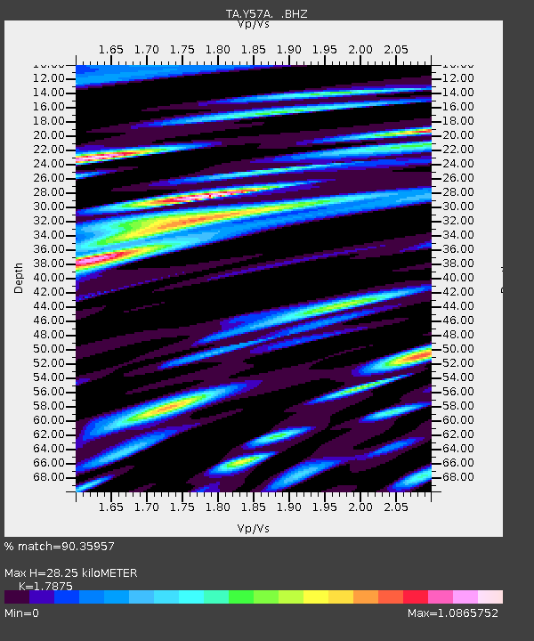
Y57A Sumter, SC, USA - Earthquake Result Viewer
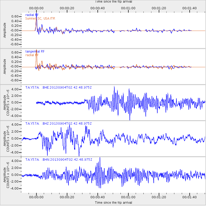
Earthquake location: Andreanof Islands, Aleutian Is.
Earthquake latitude/longitude: 51.6/-174.8
Earthquake time(UTC): 2013/09/04 (247) 02:32:30 GMT
Earthquake Depth: 20 km
Earthquake Magnitude: 6.5 MWW, 5.9 ML, 6.3 MWB, 6.5 MI, 6.5 MWC, 6.5 MWW
Earthquake Catalog/Contributor: NEIC PDE/NEIC COMCAT
Network: TA USArray Transportable Network (new EarthScope stations)
Station: Y57A Sumter, SC, USA
Lat/Lon: 34.02 N/80.39 W
Elevation: 56 m
Distance: 66.7 deg
Az: 64.381 deg
Baz: 317.335 deg
Ray Param: 0.057417236
Estimated Moho Depth: 28.25 km
Estimated Crust Vp/Vs: 1.79
Assumed Crust Vp: 6.419 km/s
Estimated Crust Vs: 3.591 km/s
Estimated Crust Poisson's Ratio: 0.27
Radial Match: 90.35957 %
Radial Bump: 400
Transverse Match: 72.34008 %
Transverse Bump: 400
SOD ConfigId: 626651
Insert Time: 2014-04-18 10:24:09.121 +0000
GWidth: 2.5
Max Bumps: 400
Tol: 0.001

Signal To Noise

ChannelStoNSTALTA
TA:Y57A: :BHZ:20130904T02:42:48.975Z6.80430031.1741041E-61.7255326E-7
TA:Y57A: :BHN:20130904T02:42:48.975Z2.36455154.530631E-71.9160636E-7
TA:Y57A: :BHE:20130904T02:42:48.975Z2.97423276.576824E-72.2112673E-7
Arrivals
Ps3.6 SECOND
PpPs12 SECOND
PsPs/PpSs15 SECOND