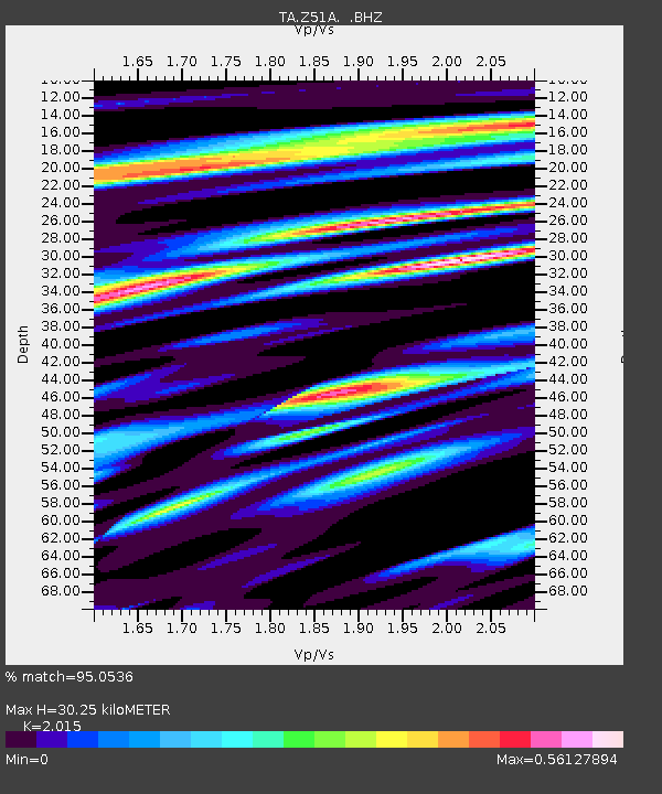
Z51A Franklin, GA, USA - Earthquake Result Viewer

Earthquake location: Andreanof Islands, Aleutian Is.
Earthquake latitude/longitude: 51.6/-174.8
Earthquake time(UTC): 2013/09/04 (247) 02:32:30 GMT
Earthquake Depth: 20 km
Earthquake Magnitude: 6.5 MWW, 5.9 ML, 6.3 MWB, 6.5 MI, 6.5 MWC, 6.5 MWW
Earthquake Catalog/Contributor: NEIC PDE/NEIC COMCAT
Network: TA USArray Transportable Network (new EarthScope stations)
Station: Z51A Franklin, GA, USA
Lat/Lon: 33.32 N/85.17 W
Elevation: 249 m
Distance: 64.5 deg
Az: 68.097 deg
Baz: 316.231 deg
Ray Param: 0.058872506
Estimated Moho Depth: 30.25 km
Estimated Crust Vp/Vs: 2.02
Assumed Crust Vp: 6.719 km/s
Estimated Crust Vs: 3.335 km/s
Estimated Crust Poisson's Ratio: 0.34
Radial Match: 95.0536 %
Radial Bump: 400
Transverse Match: 81.65942 %
Transverse Bump: 400
SOD ConfigId: 626651
Insert Time: 2014-04-18 10:24:23.488 +0000
GWidth: 2.5
Max Bumps: 400
Tol: 0.001

Signal To Noise

ChannelStoNSTALTA
TA:Z51A: :BHZ:20130904T02:42:34.649988Z8.9122377.837719E-78.7943334E-8
TA:Z51A: :BHN:20130904T02:42:34.649988Z3.42109163.0691848E-78.971361E-8
TA:Z51A: :BHE:20130904T02:42:34.649988Z3.21890262.85775E-78.8780254E-8
Arrivals
Ps4.8 SECOND
PpPs13 SECOND
PsPs/PpSs18 SECOND