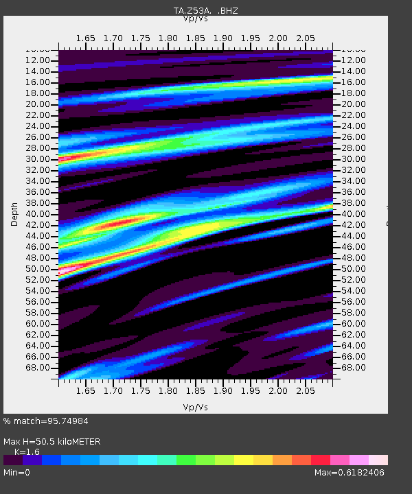
Z53A Monticello, GA, USA - Earthquake Result Viewer

Earthquake location: Andreanof Islands, Aleutian Is.
Earthquake latitude/longitude: 51.6/-174.8
Earthquake time(UTC): 2013/09/04 (247) 02:32:30 GMT
Earthquake Depth: 20 km
Earthquake Magnitude: 6.5 MWW, 5.9 ML, 6.3 MWB, 6.5 MI, 6.5 MWC, 6.5 MWW
Earthquake Catalog/Contributor: NEIC PDE/NEIC COMCAT
Network: TA USArray Transportable Network (new EarthScope stations)
Station: Z53A Monticello, GA, USA
Lat/Lon: 33.28 N/83.57 W
Elevation: 144 m
Distance: 65.4 deg
Az: 67.051 deg
Baz: 316.664 deg
Ray Param: 0.058253124
Estimated Moho Depth: 50.5 km
Estimated Crust Vp/Vs: 1.60
Assumed Crust Vp: 6.565 km/s
Estimated Crust Vs: 4.103 km/s
Estimated Crust Poisson's Ratio: 0.18
Radial Match: 95.74984 %
Radial Bump: 400
Transverse Match: 71.37845 %
Transverse Bump: 400
SOD ConfigId: 626651
Insert Time: 2014-04-18 10:24:28.428 +0000
GWidth: 2.5
Max Bumps: 400
Tol: 0.001

Signal To Noise

ChannelStoNSTALTA
TA:Z53A: :BHZ:20130904T02:42:40.824976Z6.11331657.3298145E-71.1989914E-7
TA:Z53A: :BHN:20130904T02:42:40.824976Z6.20944835.2893057E-78.5181576E-8
TA:Z53A: :BHE:20130904T02:42:40.824976Z4.19184643.6353686E-78.672476E-8
Arrivals
Ps4.8 SECOND
PpPs19 SECOND
PsPs/PpSs24 SECOND