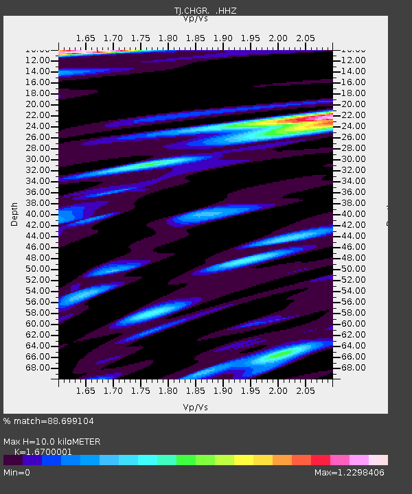
CHGR Chuyangaron, Tajikistan - Earthquake Result Viewer

Earthquake location: Andreanof Islands, Aleutian Is.
Earthquake latitude/longitude: 51.6/-174.8
Earthquake time(UTC): 2013/09/04 (247) 02:32:30 GMT
Earthquake Depth: 20 km
Earthquake Magnitude: 6.5 MWW, 5.9 ML, 6.3 MWB, 6.5 MI, 6.5 MWC, 6.5 MWW
Earthquake Catalog/Contributor: NEIC PDE/NEIC COMCAT
Network: TJ Tajikistan National Seismic Network
Station: CHGR Chuyangaron, Tajikistan
Lat/Lon: 38.66 N/69.16 E
Elevation: 1049 m
Distance: 74.3 deg
Az: 313.061 deg
Baz: 35.632 deg
Ray Param: 0.052428234
Estimated Moho Depth: 10.0 km
Estimated Crust Vp/Vs: 1.67
Assumed Crust Vp: 6.483 km/s
Estimated Crust Vs: 3.882 km/s
Estimated Crust Poisson's Ratio: 0.22
Radial Match: 88.699104 %
Radial Bump: 400
Transverse Match: 82.53678 %
Transverse Bump: 400
SOD ConfigId: 626651
Insert Time: 2014-04-18 10:24:43.178 +0000
GWidth: 2.5
Max Bumps: 400
Tol: 0.001

Signal To Noise

ChannelStoNSTALTA
TJ:CHGR: :HHZ:20130904T02:43:35.000024Z23.3203683.016797E-61.293632E-7
TJ:CHGR: :HHN:20130904T02:43:35.000024Z9.9298241.2162805E-61.2248762E-7
TJ:CHGR: :HHE:20130904T02:43:35.000024Z3.5911444.1045394E-71.1429614E-7
Arrivals
Ps1.1 SECOND
PpPs4.0 SECOND
PsPs/PpSs5.0 SECOND