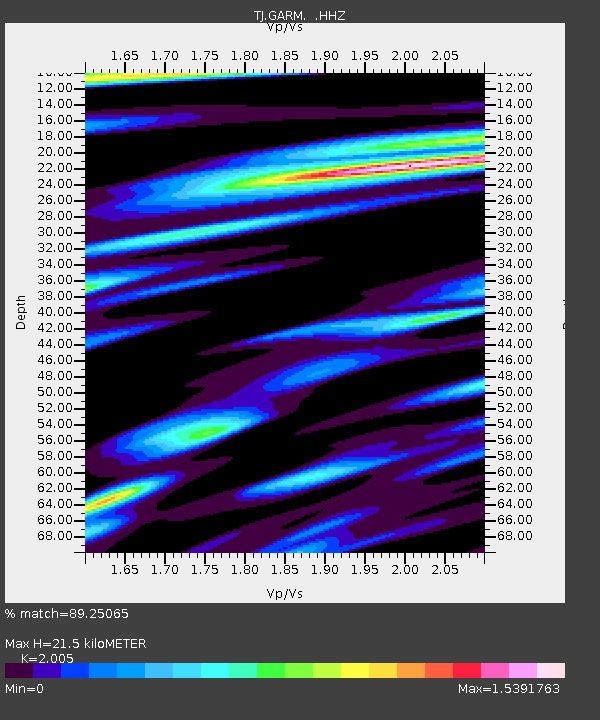
GARM Garm, Tajikistan - Earthquake Result Viewer
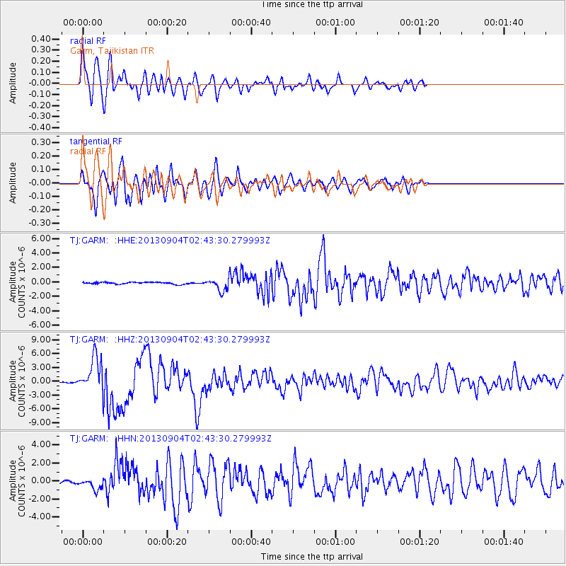
Earthquake location: Andreanof Islands, Aleutian Is.
Earthquake latitude/longitude: 51.6/-174.8
Earthquake time(UTC): 2013/09/04 (247) 02:32:30 GMT
Earthquake Depth: 20 km
Earthquake Magnitude: 6.5 MWW, 5.9 ML, 6.3 MWB, 6.5 MI, 6.5 MWC, 6.5 MWW
Earthquake Catalog/Contributor: NEIC PDE/NEIC COMCAT
Network: TJ Tajikistan National Seismic Network
Station: GARM Garm, Tajikistan
Lat/Lon: 39.00 N/70.32 E
Elevation: 1305 m
Distance: 73.5 deg
Az: 312.508 deg
Baz: 36.201 deg
Ray Param: 0.05296972
Estimated Moho Depth: 21.5 km
Estimated Crust Vp/Vs: 2.01
Assumed Crust Vp: 6.306 km/s
Estimated Crust Vs: 3.145 km/s
Estimated Crust Poisson's Ratio: 0.33
Radial Match: 89.25065 %
Radial Bump: 400
Transverse Match: 84.69224 %
Transverse Bump: 400
SOD ConfigId: 626651
Insert Time: 2014-04-18 10:24:48.641 +0000
GWidth: 2.5
Max Bumps: 400
Tol: 0.001

Signal To Noise

ChannelStoNSTALTA
TJ:GARM: :HHZ:20130904T02:43:30.279993Z23.9179553.7896073E-61.5844195E-7
TJ:GARM: :HHN:20130904T02:43:30.279993Z4.77157456.4370255E-71.349036E-7
TJ:GARM: :HHE:20130904T02:43:30.279993Z6.51318458.553569E-71.3132698E-7
Arrivals
Ps3.5 SECOND
PpPs10.0 SECOND
PsPs/PpSs13 SECOND