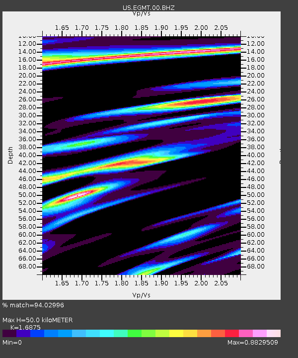
EGMT Eagleton, Montana, USA - Earthquake Result Viewer
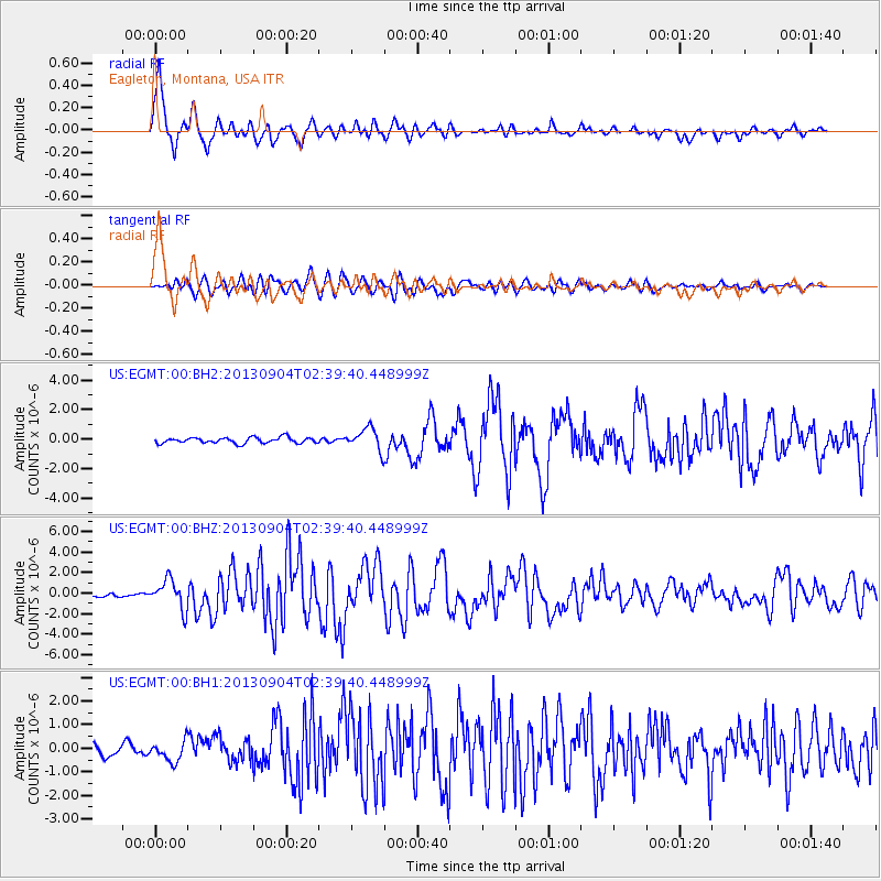
Earthquake location: Andreanof Islands, Aleutian Is.
Earthquake latitude/longitude: 51.6/-174.8
Earthquake time(UTC): 2013/09/04 (247) 02:32:30 GMT
Earthquake Depth: 20 km
Earthquake Magnitude: 6.5 MWW, 5.9 ML, 6.3 MWB, 6.5 MI, 6.5 MWC, 6.5 MWW
Earthquake Catalog/Contributor: NEIC PDE/NEIC COMCAT
Network: US United States National Seismic Network
Station: EGMT Eagleton, Montana, USA
Lat/Lon: 48.02 N/109.75 W
Elevation: 1055 m
Distance: 40.9 deg
Az: 68.377 deg
Baz: 300.171 deg
Ray Param: 0.074110284
Estimated Moho Depth: 50.0 km
Estimated Crust Vp/Vs: 1.69
Assumed Crust Vp: 6.438 km/s
Estimated Crust Vs: 3.815 km/s
Estimated Crust Poisson's Ratio: 0.23
Radial Match: 94.02996 %
Radial Bump: 400
Transverse Match: 78.87057 %
Transverse Bump: 400
SOD ConfigId: 626651
Insert Time: 2014-04-18 10:25:59.601 +0000
GWidth: 2.5
Max Bumps: 400
Tol: 0.001

Signal To Noise

ChannelStoNSTALTA
US:EGMT:00:BHZ:20130904T02:39:40.448999Z8.3331671.4187228E-61.7025013E-7
US:EGMT:00:BH1:20130904T02:39:40.448999Z1.50845854.192105E-72.7790654E-7
US:EGMT:00:BH2:20130904T02:39:40.448999Z3.85997187.505575E-71.9444637E-7
Arrivals
Ps5.7 SECOND
PpPs19 SECOND
PsPs/PpSs25 SECOND