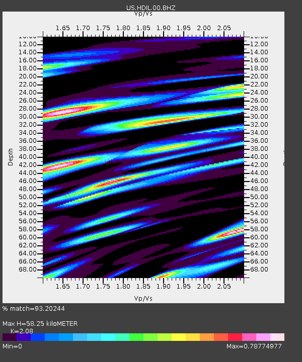
HDIL Hopedale, Illinois, USA - Earthquake Result Viewer

Earthquake location: Andreanof Islands, Aleutian Is.
Earthquake latitude/longitude: 51.6/-174.8
Earthquake time(UTC): 2013/09/04 (247) 02:32:30 GMT
Earthquake Depth: 20 km
Earthquake Magnitude: 6.5 MWW, 5.9 ML, 6.3 MWB, 6.5 MI, 6.5 MWC, 6.5 MWW
Earthquake Catalog/Contributor: NEIC PDE/NEIC COMCAT
Network: US United States National Seismic Network
Station: HDIL Hopedale, Illinois, USA
Lat/Lon: 40.56 N/89.29 W
Elevation: 219 m
Distance: 57.1 deg
Az: 64.804 deg
Baz: 312.149 deg
Ray Param: 0.06369841
Estimated Moho Depth: 58.25 km
Estimated Crust Vp/Vs: 2.08
Assumed Crust Vp: 6.498 km/s
Estimated Crust Vs: 3.124 km/s
Estimated Crust Poisson's Ratio: 0.35
Radial Match: 93.20244 %
Radial Bump: 400
Transverse Match: 75.20358 %
Transverse Bump: 400
SOD ConfigId: 626651
Insert Time: 2014-04-18 10:26:18.615 +0000
GWidth: 2.5
Max Bumps: 400
Tol: 0.001

Signal To Noise

ChannelStoNSTALTA
US:HDIL:00:BHZ:20130904T02:41:44.350Z5.5499931.1619292E-62.0935687E-7
US:HDIL:00:BH1:20130904T02:41:44.350Z2.79066136.6534693E-72.384191E-7
US:HDIL:00:BH2:20130904T02:41:44.350Z3.19902595.875312E-71.8365941E-7
Arrivals
Ps10 SECOND
PpPs26 SECOND
PsPs/PpSs37 SECOND