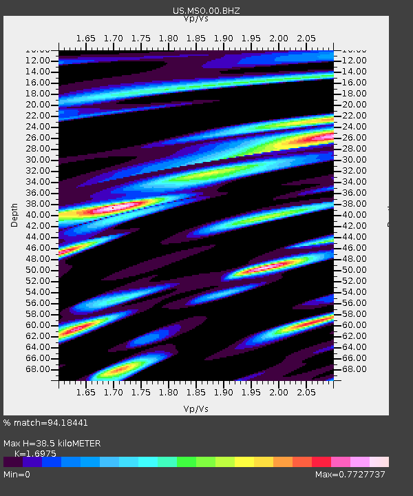
MSO Missoula, Montana, USA - Earthquake Result Viewer
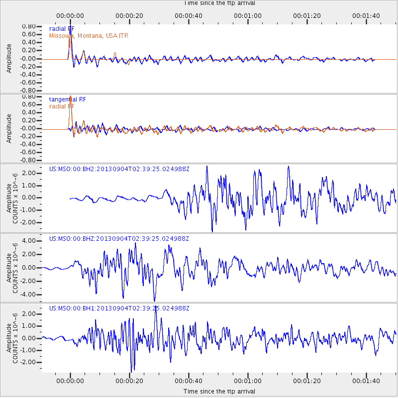
Earthquake location: Andreanof Islands, Aleutian Is.
Earthquake latitude/longitude: 51.6/-174.8
Earthquake time(UTC): 2013/09/04 (247) 02:32:30 GMT
Earthquake Depth: 20 km
Earthquake Magnitude: 6.5 MWW, 5.9 ML, 6.3 MWB, 6.5 MI, 6.5 MWC, 6.5 MWW
Earthquake Catalog/Contributor: NEIC PDE/NEIC COMCAT
Network: US United States National Seismic Network
Station: MSO Missoula, Montana, USA
Lat/Lon: 46.83 N/113.94 W
Elevation: 1264 m
Distance: 39.0 deg
Az: 72.206 deg
Baz: 300.033 deg
Ray Param: 0.0751984
Estimated Moho Depth: 38.5 km
Estimated Crust Vp/Vs: 1.70
Assumed Crust Vp: 6.353 km/s
Estimated Crust Vs: 3.743 km/s
Estimated Crust Poisson's Ratio: 0.23
Radial Match: 94.18441 %
Radial Bump: 400
Transverse Match: 81.51254 %
Transverse Bump: 400
SOD ConfigId: 626651
Insert Time: 2014-04-18 10:26:49.751 +0000
GWidth: 2.5
Max Bumps: 400
Tol: 0.001

Signal To Noise

ChannelStoNSTALTA
US:MSO:00:BHZ:20130904T02:39:25.024988Z5.04438737.336898E-71.4544676E-7
US:MSO:00:BH1:20130904T02:39:25.024988Z2.95539762.449287E-78.287505E-8
US:MSO:00:BH2:20130904T02:39:25.024988Z2.9768843.769575E-71.2662821E-7
Arrivals
Ps4.5 SECOND
PpPs15 SECOND
PsPs/PpSs20 SECOND